The Karamatura to Mount Donald McLean trail is a must-do when exploring the Waitākere Ranges. It’s a hike that combines lush native bush, a waterfall, and panoramic views of the city and West Coast. It’s also one of my personal favourites of 2025.
Even though it is a challenge with stairs galore, it’s so worth the effort and I hope the below convinces you that it’s worth the time to explore.
This post may contain affiliate links. Your purchase through these links supports me with a commission, at no added expense to you.
KEY TAKEAWAYS
- This is your complete guide to the Karamatura to Mount Donald McLean track – a rewarding day hike in the Waitākere Ranges that delivers lush native bush, a swimmable waterfall, and epic panoramic views over Auckland city, Manukau Harbour, Whatipu Beach, and the wild West Coast.
- It’s one of Auckland’s best-kept secrets: just 40km from the CBD, yet it feels worlds away, making it perfect for locals and visitors who want a proper New Zealand outdoor experience.
- You’ll learn exactly how to get there, where to park, what the trail is really like (stairs, views, and all), the best times to go for fewer crowds and great conditions, solo-hiking safety tips, photography and drone advice, plus nearby attractions to turn it into a full day out.
- By the end, you’ll know whether the full 11.3 km return is for you or if the shorter summit option works better.
KARAMATURA TO MOUNT DONALD MCLEAN LOCATION
The location of the Karamatura to Mount Donald McLean trail is in the Waitākere Ranges Regional Park. You can find it approximately 40km southwest of Auckland’s CBD.
HOW TO GET TO THE TRAILHEAD
From Auckland, take State Highway 16 west, then follow signs to Titirangi and continue on Huia Road. Just before the Huia Settlers Museum, you’ll see a gravel road to your right. This then leads to the carpark.
The Karamatura carpark is a little hidden, so for ease I have included the exact location here.
Parking tips
The carpark is a decent-sized gravel area with space for several vehicles but it can fill up quickly on weekends. We were lucky enough to nab a park as someone was leaving. However, if you aren’t able to get a park here, the Huia Settlers Museum is another great option and is just a short walk to the trailhead.

KEY INSIGHTS FOR HIKING KARAMATURA TO MOUNT DONALD MCLEAN
Distance: 11.3 km | 7 miles
Elevation: 652 meters
Duration: 3 hours
Difficulty: Medium
Trail Type: There-and-back, including small loop
Open: Year-round
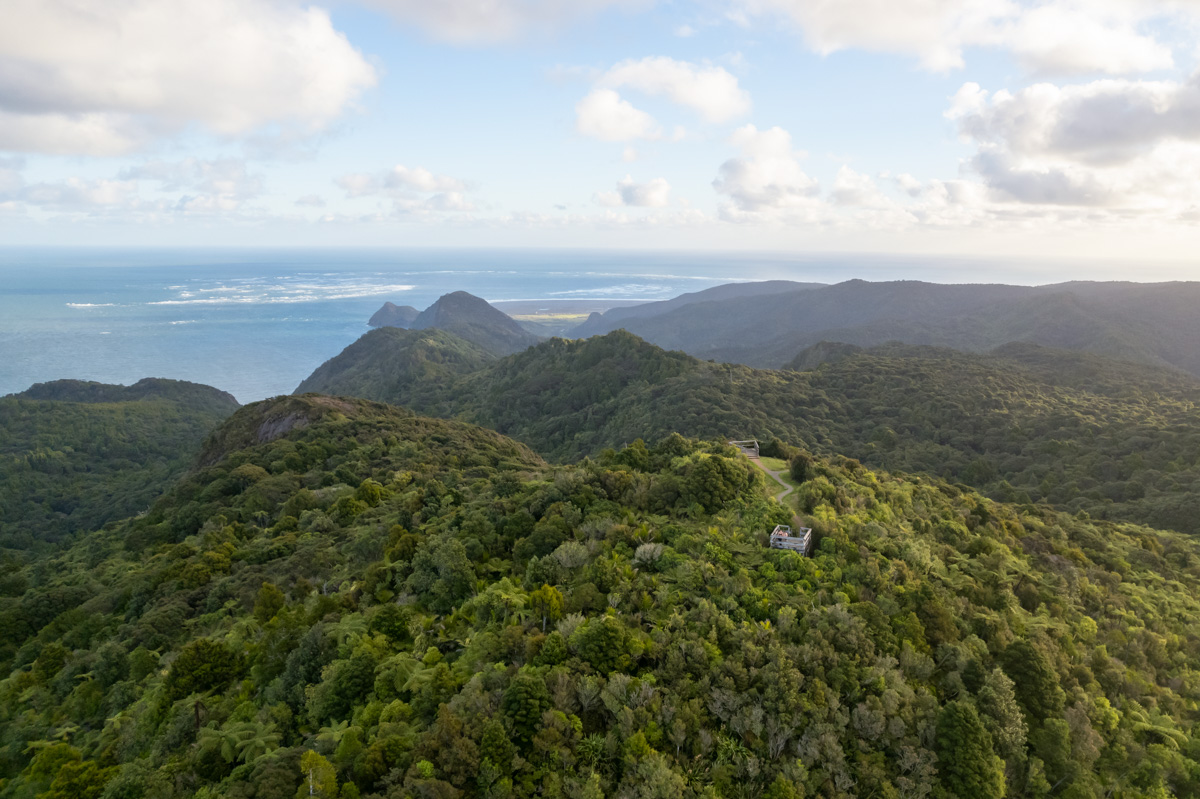
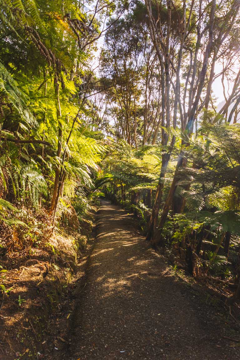
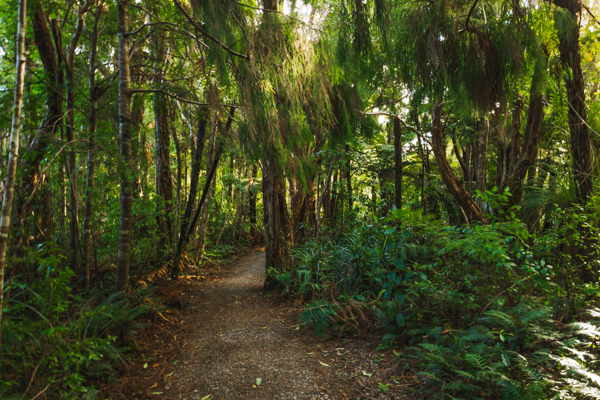
The Karamatura to Mount Donald McLean Track kicks off with a gentle incline, through lush native bush on a well-maintained path. The boardwalks and clear trail make for an easy start but don’t be fooled, it does get tougher.
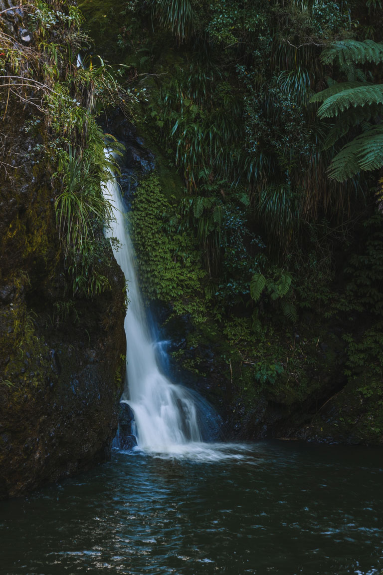
Not far in, you’ll reach Karamatura Falls. This is a solid excuse to stop and cool off with a dip during the warmer months. From here, the ascent does become steeper, with a series of steps and switchbacks so it’s definitely a leg burner. I found myself pausing often, usually when there was a break in the trees and a killer view. Convenient, really.
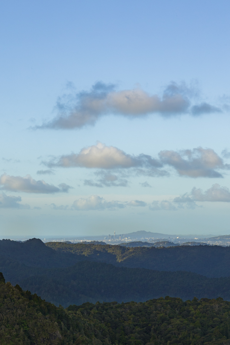
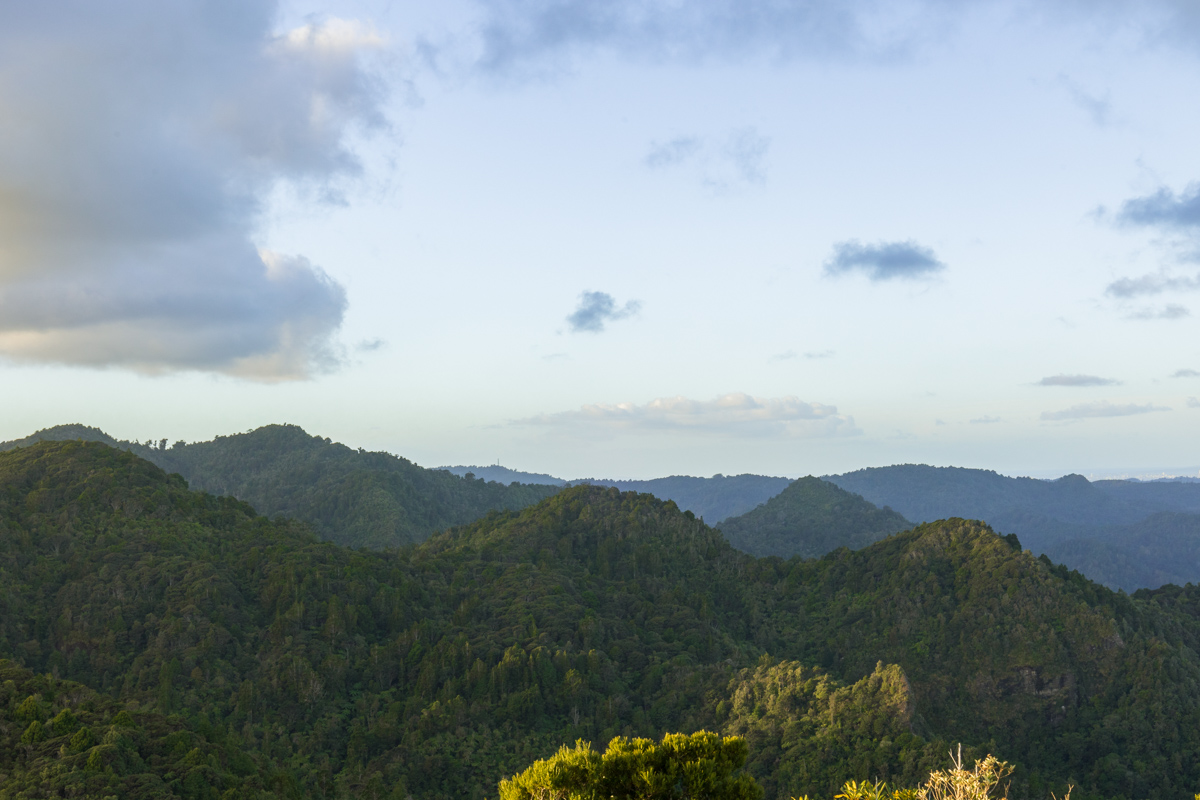
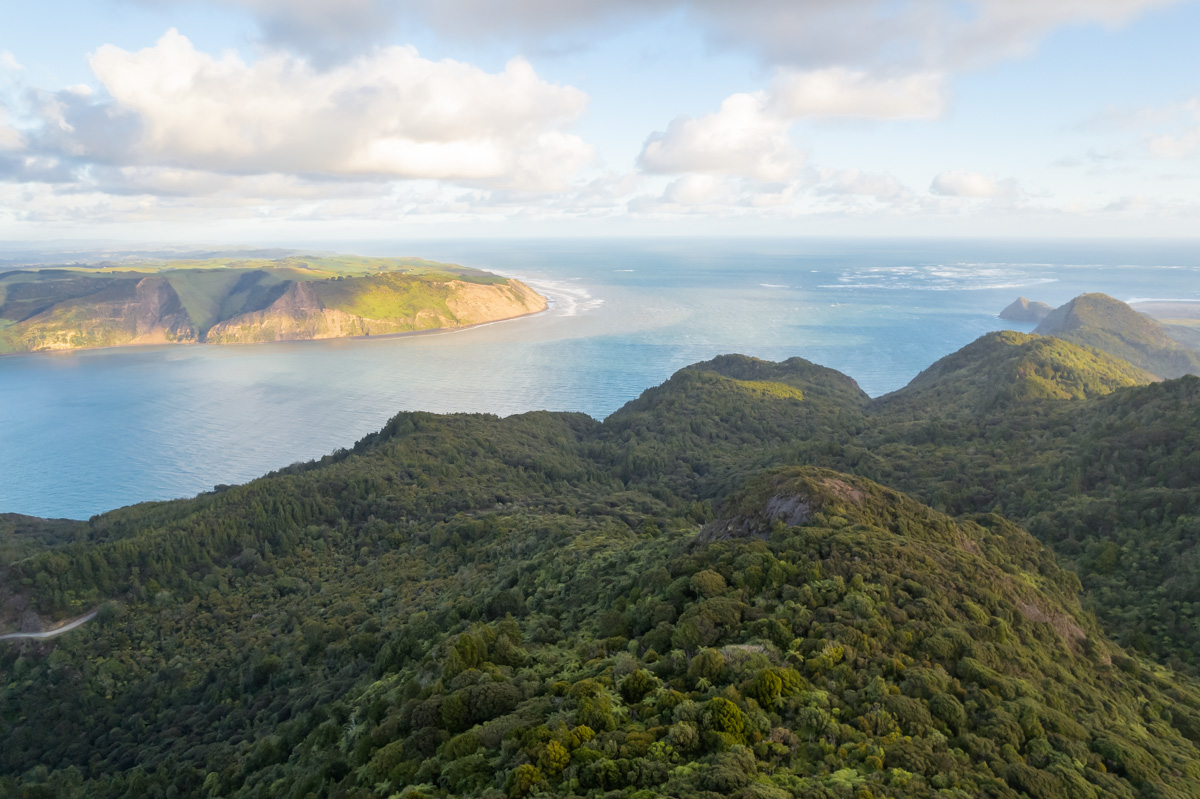
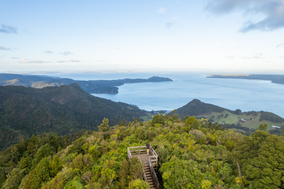
The mix of stairs and boardwalks continues for most of the track, but things start to open up in the final 10-15 minutes. You’ll catch more and more glimpses of the incredible views you’ve worked for. And when you reach the summit, damn. The panorama stretches across the Waitākere Ranges, over Whatipu Beach and Manukau Harbour, all the way out to Auckland city.
The return trip is quicker (thankfully). What you climbed up, you now descend, so how fast you move kind of depends on how friendly your body is feeling post climb.
If you’re keen to change it up on the way back, I recommend diverting onto the Karamatura Stream Track. It’s a peaceful way to wind down after the climb, finishing on a high note.
And if the full hike sounds like a bit much, there’s actually a second option: a nearby carpark just a short 10 minute walk from the summit. You’ll still score those amazing views without the full climb. But honestly? I’d still suggest doing the entire walk if you can. You get the full experience–forest, waterfalls, changing scenery, and those rewarding lookout points along the way.
It’s a proper New Zealand day hike, start to finish.

BEST TIME TO VISIT
The Karamatura to Mount Donald McLean trail is accessible year-round, but the best conditions are typically found in summer. This is when you’ll have longer daylight hours and much more weather stability. Late spring and early autumn/fall are also great times to visit. We did this hike in mid-May and managed to get a really nice evening. This was also a great time to avoid others on the trail as most people opt for mid-morning or early afternoon walks.
HOW CROWDED IS IT HIKING KARAMATURA TO MOUNT DONALD MCLEAN
The Karamatura to Mount Donald McLean trail isn’t as popular as the Omanawanui trail which is located further into the Waitākere Ranges. Weekends are definitely busier than the weekdays and as mentioned earlier, most people opt for mid-morning or early afternoon walks, so either an early morning, later in the evening or weekday hikes are recommended for a quieter experience.
IS IT SAFE TO TRAVEL KARAMATURA TO MOUNT DONALD MCLEAN SOLO?
Yes, this trail is definitely safe for solo travellers. We came across a couple of solo hikers whilst exploring the trail ourselves. As it is well-marked and frequented by other walkers, it is a great option for those travelling alone. However, always inform someone of your plans, carry sufficient water, and be prepared for changing weather conditions.
PHOTOGRAPHING THE TRAIL
Those who love diversity in scenery will appreciate the Karamatura to Mount Donald McLean hike. You’ll have everything from dense, native bush to panoramic views at the summit. The Karamatura Falls, a short detour from the main trail, also offers a picturesque spot to experiment with long-exposure shots.
You’ll be manually updating your settings plenty on this trail with the constant change in lighting but it’s well worth it for the beautiful photographs you’ll capture. The summit was a favourite of mine (surprise, surprise) with being surrounded by the Waitākere Ranges. Being a vast, open space at the summit it also makes it easy to launch and land a drone which I took every opportunity to do.
OTHER HIKES/LOOKOUTS NEARBY
This trail is so close to many other amazing lookouts and hikes being located in the Waitākere Ranges. Here are a couple of favourites:
- Omanawanui: This is a hike closer to the coast and Whatipu Beach. It has similar views and again, many stairs but the views are similar and equally as incredible as Karamatura to Mount Donald McLean.
- Whatipu Beach: This is a black sand, rugged west coast beach which offers an amazing sunset. Definitely a place I would recommend visiting, additionally to the Karamatura hike.
- Huia Lookout: This is just a short walk that requires really minimal effort but is a stunning lookout that looks up the coast and across Manukau Harbour.
There are so many more adventures in the region. For more, check out more of my guides on New Zealand’s ultimate destinations.
SUMMARY
In this post, we’ve explored the Karamatura to Mount Donald McLean trail, highlighting its key features, best visiting times, and nearby attractions. Whether you’re in for the views or the challenge of the walk, this trail offers one of the best outdoor experiences close to Auckland.
Looking for more hiking inspiration? Explore my NZ hiking guides or if you’re looking for even more adventures feel free to browse my comprehensive travel destination guides.
LIKE THIS POST? PIN IT HERE
FAQs
How difficult is the Karamatura to Mount Donald McLean track?
It’s rated medium overall but feels harder because of the sheer number of stairs (it’s commonly reported as 1,200–1,500 steps). The first section is gentle and well-maintained with boardwalks, but the climb to the summit is a solid leg burner. Fit hikers manage it comfortably; beginners or anyone with knee issues should take it slow and use trekking poles.
How long does the hike take and how far is it?
The full there-and-back is 11.3 km with 652 m elevation gain. Most people take 3–5 hours including stops at the falls and summit. The return is noticeably quicker on the way down.
Is there a shorter option if I don’t want the full hike?
Yes! There’s a second carpark only a 10 minute walk from the summit. You’ll still get the same incredible views without the big climb, but you’ll miss the forest, waterfall, and full experience. Most people who try the short version end up wishing they’d done the whole thing.
Can I swim at Karamatura Falls?
Absolutely. Unfortunately I didn’t have enough time but I’ve heard it’s one of the highlights! There’s a safe, deep swimming hole at the base that’s popular in warmer months. The water is cold (even in summer), but very refreshing after the climb.
What’s the best time of year and day to do this hike?
Year-round access, but summer (Dec–Feb) offers the best weather and swimming. Late spring and early autumn are also excellent. For fewer people, go early morning, late afternoon/evening, or on weekdays.
Is it safe to hike solo?
Yes. The track is well-marked, well-maintained, and sees regular foot traffic. We passed several solo hikers. As always, tell someone your plans, take plenty of water, check the weather, and carry a personal locator beacon or charged phone if you’re going alone.
Is the track affected by kauri dieback closures?
No, this trail is fully open. Always check the latest Auckland Council or AllTrails updates before you go, and clean your boots at any stations provided.
What should I bring and are there any facilities?
There are no toilets or water at the trailhead. Bring water, snacks, rain jacket (West Coast weather can change fast), sun protection, and sturdy shoes. Trekking poles are very helpful on the stairs.
How does it compare to the Omanawanui Track?
The views at both summits are very similar and both have heaps of stairs and epic coastal/West Coast views – but Karamatura feels quieter and less crowded. There is also much more forest sections than Omanawanui which is mostly exposed and feels more like you are walking the ridge line.
Top Travel Resources to Plan Your Next Trip
Finding the Best Flights
Skyscanner: A great platform for comparing flight prices across airlines and routes.
Omio: Perfect for comparing not just flights but also trains and buses, especially for European travel.
Booking Your Stay
Hostelworld: Ideal for those specifically looking to budget on their travels and seeking hostels, guesthouses, or shared accommodations.
Booking.com: With a massive selection of hotels, apartments, and unique stays, this platform additionally has deals for frequent travellers.
Discovering Amazing Activities
GetYourGuide: My go-to for booking tours, tickets, and activities in New Zealand and worldwide.
Everything New Zealand: A must for anyone traveling to New Zealand. This platform offers a curated selection of tours, activities, and adventures to make your Kiwi trip epic.
G Adventures: For small-group tours with a focus on sustainable and authentic travel, G Adventures is unbeatable.
Capturing Your Memories
MILK Books: Create stunning photo books to preserve your travel memories. Expect high-quality prints and customisable designs.
These links are affiliate links. If you book through them, I earn a small commission at no extra cost to you. Your support helps me keep sharing guides like this. Thanks for helping fuel the next adventure!
LATEST FROM THE BLOG
A SUMMARY OF KARAMATURA TO MOUNT DONALD MCLEAN TRAIL
- Trail Overview: Medium 11.3 km (7 mi) there-and-back (with optional small loop) hike in Waitākere Ranges Regional Park, 40 km southwest of Auckland CBD. Combines lush native bush, boardwalks, Karamatura Falls (great for swimming in summer), steep stair sections, and jaw-dropping 360° summit views across the Waitākere Ranges, Whatipu Beach, Manukau Harbour, and Auckland city skyline. Shorter summit-only option available from a second carpark.
- Key Stats: Distance: 11.3 km return. Elevation: 652 m. Duration: 3–5 hours. Difficulty: Medium (lots of stairs and switchbacks). Trail Type: There-and-back with optional loop. Open year-round. Free entry.
- Best For: Auckland locals and visitors wanting a rewarding, uncrowded day hike. Ideal for photographers, drone pilots, nature lovers, fit hikers, and anyone after forest-to-summit variety with waterfall swims and panoramic payoffs. Great half-day or full-day adventure.
- Access & Logistics: Start at Karamatura carpark (gravel lot off Huia Road, near Huia Settlers Museum – use Google Maps pin provided). 40–50 min drive from Auckland CBD via SH16. Alternative summit carpark for shorter version. Check Metservice for Waitākere weather; track can be slippery after rain.
- Tips: Go early morning or late afternoon for golden light, fewer crowds, and better parking. Carry water/snacks and trekking poles for the stairs. Swim at Karamatura Falls in warmer months. Return via Karamatura Stream Track for a peaceful finish. Tell someone your plans if solo.
- Nearby Attractions: Omanawanui Track, Whatipu Beach, Huia Lookout. Plenty more Waitākere adventures and day-trip options.
- Safety & Practicality: Well-marked and solo-friendly track. Watch for changing West Coast weather, use kauri dieback cleaning stations, and check Auckland Council for any temporary closures. No facilities at trailhead. Sturdy footwear essential.