When I think about the best hikes with a view, especially living in the North Island of New Zealand, I’m spoiled for choice with trails that deliver jaw-dropping scenery.
If you’re travelling New Zealand for the first-time or are interested in hiking, these trails should definitely be added onto your adventure list. Not only do they offer epic trails, but they’re also aesthetically pretty stunning too. From coastal cliffs to volcanic summits, I’ve rounded up the best hikes with a view in North Island, New Zealand, with insider tips to help you plan your trek.
So, lace up your boots and dive into this guide for all the details you need!
This post may contain affiliate links. Your purchase through these links supports me with a commission, at no added expense to you.
OMANAWA FALLS, BAY OF PLENTY
Location: Bay of Plenty
Distance: 7.7 km | 4.8 miles
Elevation: 347m
Duration: 2–3 hours
Difficulty: Easy–Moderate
Trail Type: There-and-back
Open: Year-round
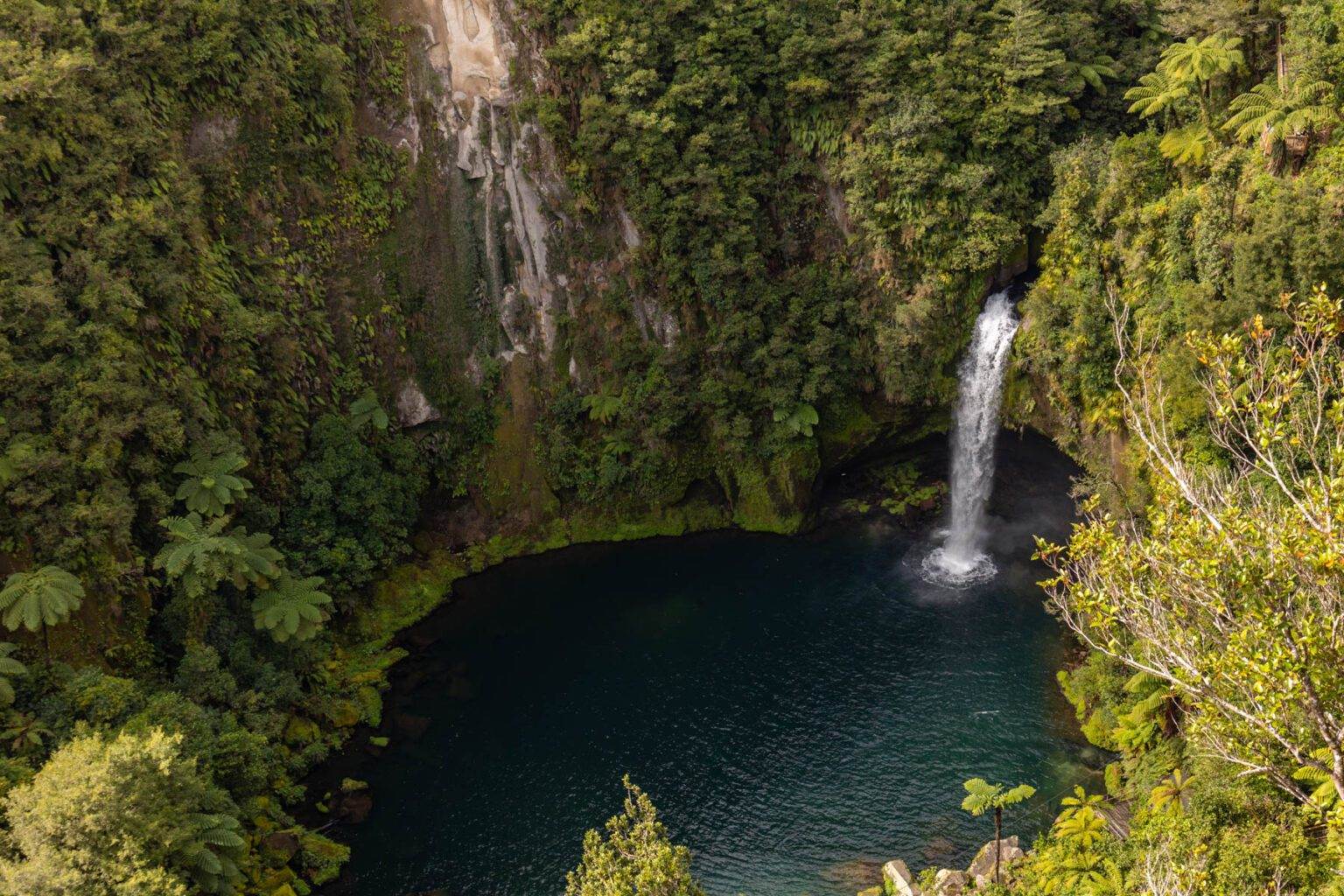
Looking for a nature fix with stunning waterfall views? You’ll find Omanawa Falls, just outside Tauranga, is a Bay of Plenty gem that easily ranks among the best hikes with a view in the North Island.
This 2.7 km there-and-back trail, reopened in December 2023 after years of closure and now boasts upgraded paths. Firstly, you’ll wander through lush native forest, with several lookout points showcasing the cascading falls. Stopping at Wairere Tapu is a must for a great view, but if you’re up for a bit more adventure, tackle the 750 steps to Te Harikoa Lookout.
The trail’s manageable for most, but the step-heavy route to Te Harikoa bumps up the challenge slightly. Make sure to check the Tauranga City website for a detailed trail map to plan your route, or dive into my full Omanawa Falls guide here for all the insider tips.
BELL ROCK, HAWKE’S BAY
Location: Hawke’s Bay
Distance: 7.2 km | 4.5 miles
Elevation: 350 meters
Duration: 2.5–3 hours
Difficulty: Medium
Trail Type: There-and-back + loop
Open: Year-round
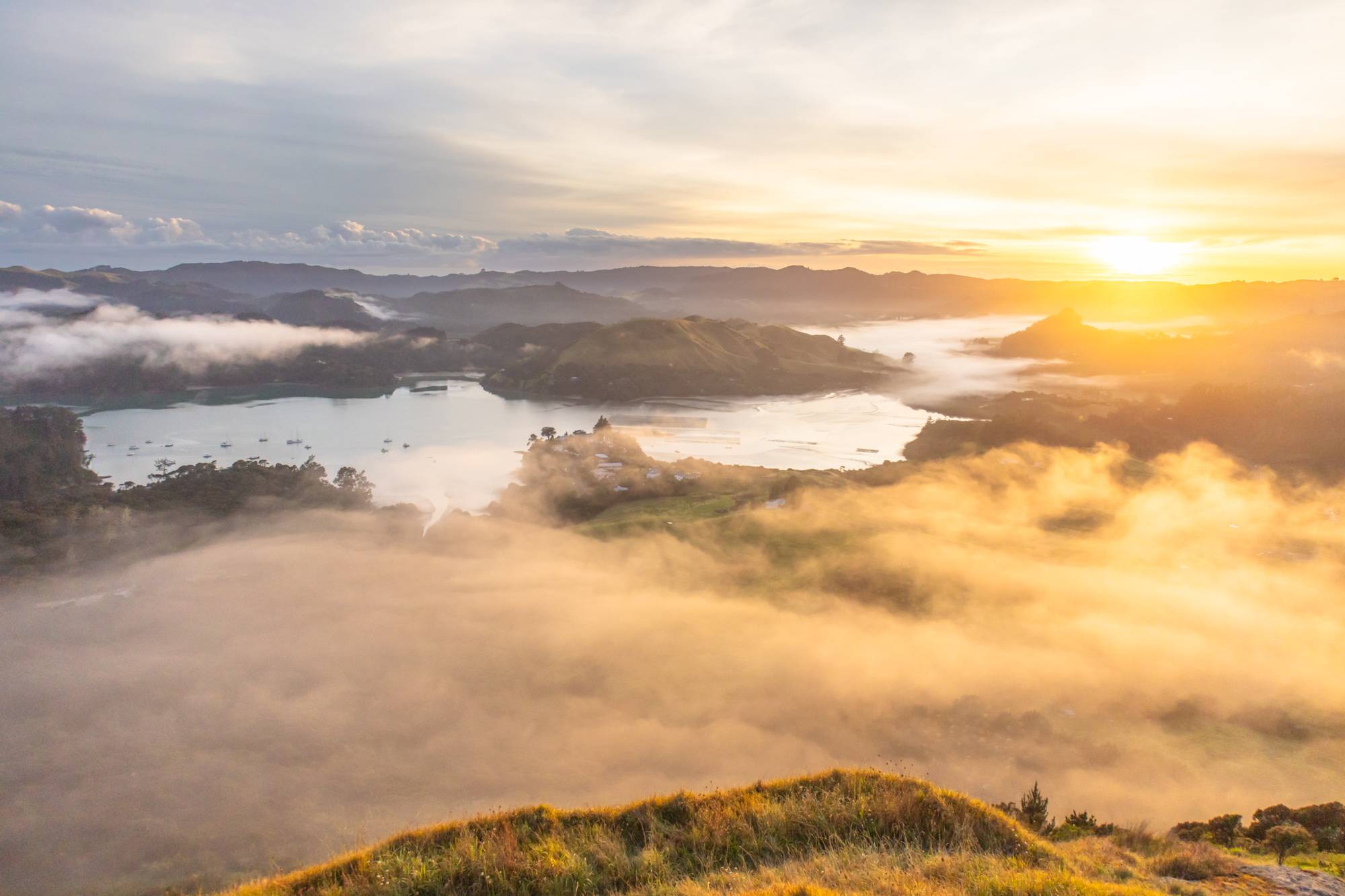
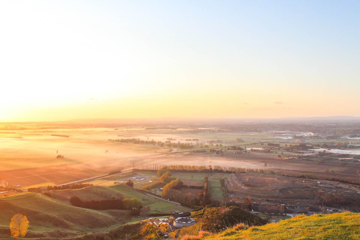
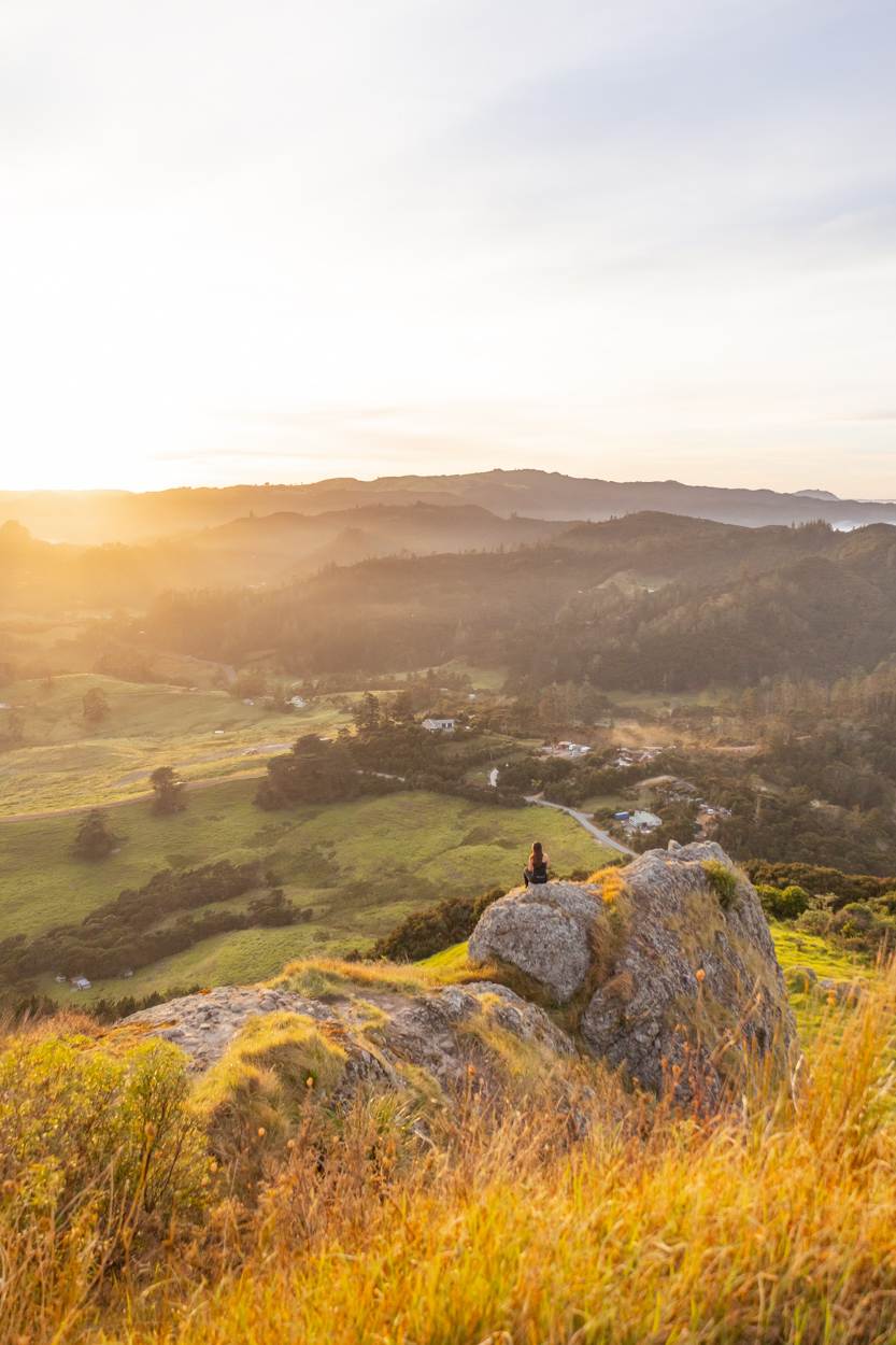
If you’re after East Coast drama with a golden hour twist, you’ll find Bell Rock in Hawke’s Bay is a standout for one of the best hikes with a view. About 1.5 hours from Napier, with stunning scenery en route, this 7.2 km loop blends shady forests, sunny farmlands, and a cliff-edge path.
As you reach closer to Bell Rock, you’ll have panoramic views of Mahia Peninsula and the Kaweka mountain range. I hit the trail first thing and I was lucky that this particular morning there was a cloud inversion. Consequently, paired with sunrise really only made this spot even better.
The path does get a bit slippery post-rain and pollen-heavy in spots (grab tissues if allergies are your nemesis), so layer up for wind and slather on the sunscreen for those open stretches. Afterwards, you can always treat yourself to a winery pit stop nearby.
It’s a hidden Hawke’s Bay hero that rewards the effort with views you’ll be glad you made the effort to see. For more details, check out my full guide on Bell Rock in the Hawkes Bay here.
TE HENGA WALKWAY, AUCKLAND
Location: West Coast, Auckland
Distance: 3.7 km | 2.2 miles
Elevation: 170 meters
Duration: 1 hour 20 minutes
Difficulty: Easy
Trail Type: There-and-back
Open: Year-round
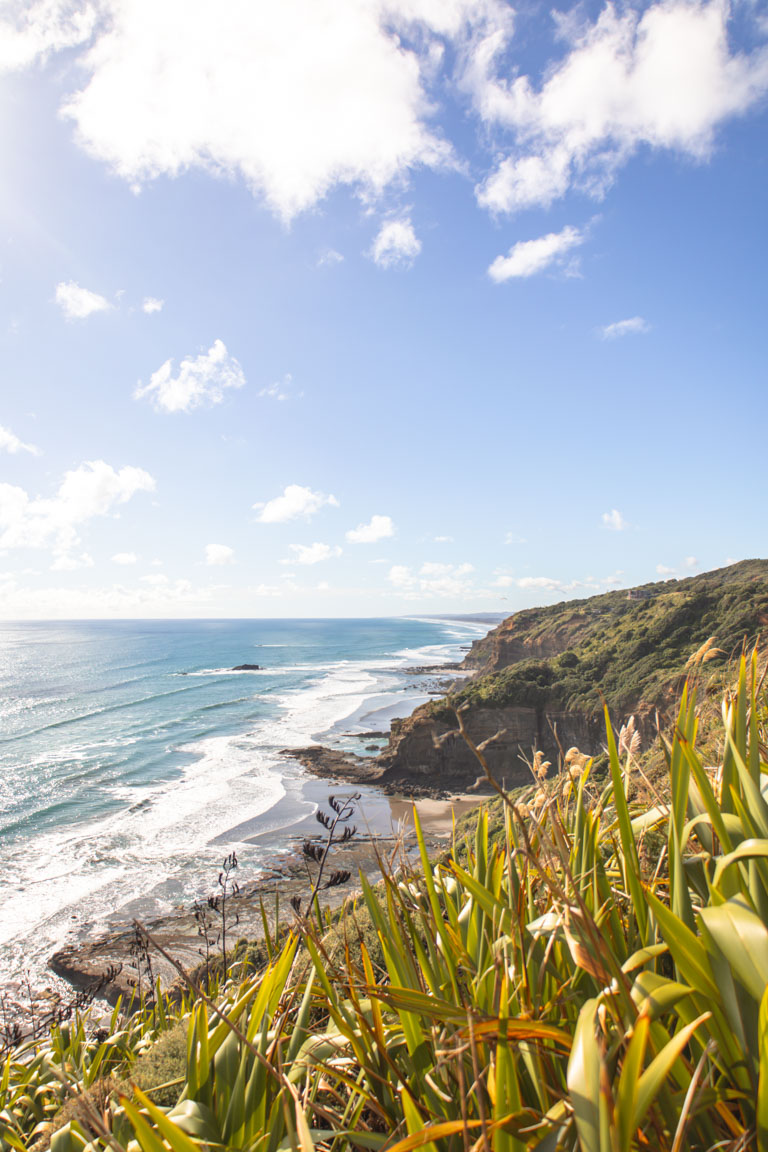
Looking for a quick coastal escape from Auckland’s hustle and bustle? You’ll love the Te Henga Walkway, a 3.7 km gem in the Waitākere Ranges. Part of the Hillary Trail (partially closed since 2023), this reopened section starts at Constable Road near Bethells Beach and winds through farmland and native bush to two stunning viewpoints which showcases that this is one of the best hikes with a view: Cliff Viewpoint and Tirikohua Point.
Expect views that sweep from Muriwai to Bethells and pair it with a sunset at Muriwai Beach. Check the Department of Conservation (DOC) website for track updates, and dive into my full Te Henga guide for more tips.
PAPAMOA HILLS, BAY OF PLENTY
Location: Papamoa, Bay of Plenty
Distance: 3.7 km | 2.3 miles
Elevation: 200m
Duration: 1 hour 15 minutes
Difficulty: Easy
Trail Type: There-and-back
Open: Year-round
Craving some coastal views? You’ll love Papamoa Hills Regional Park in the Bay of Plenty. It’s a quick win that you’ll find just 20 minutes from Tauranga. The 3.7 km summit trail has recently had an upgrade so the trail is easy to follow. It’ll take you through open grasslands and farmland and once at the summit you’ll have unreal 360 degree views of the endless Pacific Ocean, Mount Maunganui and hints of the Waikato.
I’m a sucker for sunrise here. In fact, it’s peaceful, and way less crowded than nearby spots (like Mount Maunganui).
The trail’s super accessible, especially with the shiny new carpark, but pack water, snacks, and sun gear since it’s mostly unshaded.
Whether it’s a solo walk or a family stroll, this one’s a Bay of Plenty essential that you should be on your list. Want the full scoop? I’ve written a deep-dive on Papamoa Hills over here.
KARAMATURA TO MOUNT DONALD MCLEAN, AUCKLAND
Location: Waitākere Ranges, Auckland
Distance: 11.3 km | 7 miles
Elevation: 652 meters
Duration: 3 hours
Difficulty: Medium
Trail Type: There-and-back, including small loop
Open: Year-round
Keen for a West Coast sunset with a side of serene forest? You’ll find Mount Donald McLean in the Waitākere Ranges is your spot for one of the best hikes with a view in the North Island.
This 11.3 km out-and-back trail kicks off in the lush Karamatura Valley, winding up through native bush to two epic ridgeline viewpoints. Once at the top you’ll notice one looks west to the rugged Whatipū Beach, while the other gazes east toward Auckland’s skyline. Both which deliver beautiful views over the Waitākere Ranges and Manukau Harbour. If you’ve got a drone, this is the place to fly it.
You’ll see on AllTrails that there is some serious amount of elevation and that’s due to the amount of stairs. But, if you are short on time there is a carpark that’s is a quick 10 minute walk to the summit.
This is a very similar lookout to Omanawanui Track not far from here, but a little more shaded with slightly different views. For more details on the Karamatura to Mount Donald McLean trail, check out my full guide here.

MOUNT EDEN, AUCKLAND
Location: Auckland
Distance: 2.1 km | 1.3 miles
Elevation: 76m
Duration: 30 minutes – 1 hour
Difficulty: Easy
Trail Type: Loop
Open: Year-round
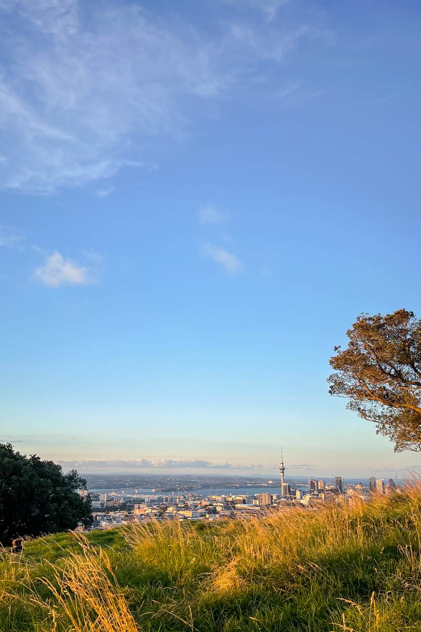
Want one of the best hikes with a view without leaving Auckland? You’ll love Mount Eden, just 5 km from the city centre. This dormant volcano (last active 5,000 years ago) offers a quick 10–15 minute walk to a 196 meter summit.
The loop trail rewards you with 360 views of Auckland’s skyline, including the Sky Tower, Waitematā Harbour, and nearby volcanic cones. Trust me, the grassy crater and open ridge lines make it a perfect spot to spend some time, especially during golden hour or blue hour when the city lights start to twinkle.
It’s easily accessible and stunning, ideal for sunrise or sunset seekers. Note: the carpark gate has restricted hours, but walk-ins are welcome anytime.
DUKES NOSE LOOKOUT, NORTHLAND
Location: Bay of Islands
Distance: 10.8km | 6.7 miles
Elevation: 518m
Duration: 5-6 hours
Difficulty: Moderate (Difficult in parts)
Trail Type: There-and-back
Open: Year-round
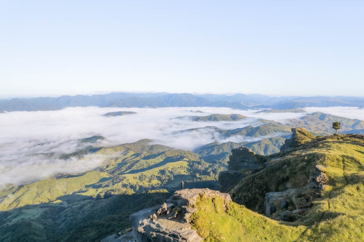
Just a short drive from Whāngarei, this 10.8 km trail takes about 5–6 hours to complete and once you’re at the top you’ll have insane 360 degree views over Waitepipi, Te Were, and Pekapeka Bays. I can undeniably say that it’s one of the best views in Northland and the North Island.
The path takes you through native forest for most of the journey, with a steady climb that ramps up to a steep final push to the summit. I’ve tackled this hike twice at sunrise, and both times, we had the lookout to ourselves. However, this is where I need to pop in a warning. Be prepared to encounter swampy patches and stream crossings. You’ll need some balance, sturdy shoes and a headlamp for early starts.
This hike is perfect for those who want a challenge with stunning views. Ready to plan your trip? Dive into my full Dukes Nose guide here.
MOUNT TAUHARA, TAUPŌ
Location: Taupō
Distance: 7.3 km | 4.5 miles
Elevation: 520 meters
Duration: 2 hours
Difficulty: Medium
Trail Type: There-and-back
Open: Year-round
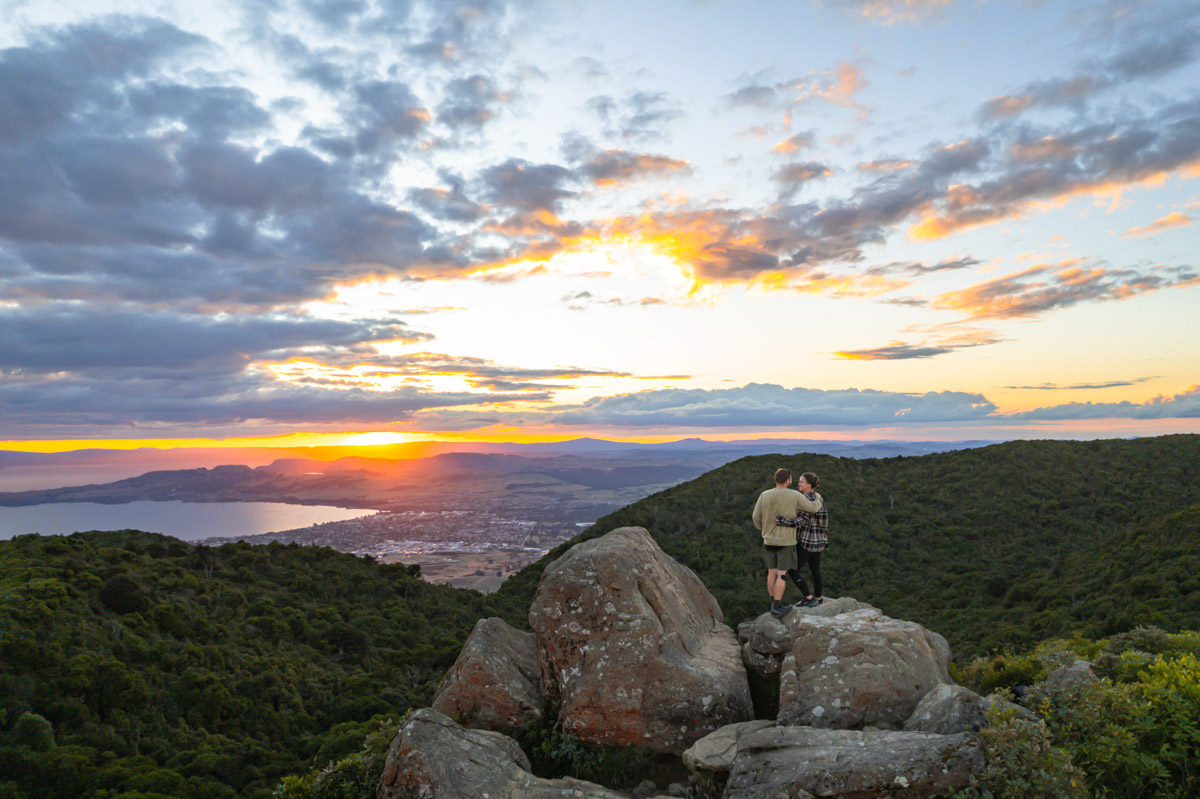
Just a 10-minute drive from Taupō, you’ll find Mount Tauhara, an extinct stratovolcano which offers a 7.3 km hike with big rewards.
This out-and-back path starts with a stretch through open farmland before diving into shady native forest. There’s a gradual incline and once you reach the summit, you’ll have views of Lake Taupō and the distant Mount Ruapehu. We did this hike at sunset and it was particularly magical during golden hour.
While in Taupō, don’t miss other gems like Huka Falls, the waterfront, or the Māori Rock Carvings. This is one of those best hikes with a view that is perfect to combine with other activities in the area.
If you’re curious to know more, I’ve covered the Mount Tauhara in more depth in this blog post.
ST PAULS ROCK, NORTHLAND
Location: Bay of Islands
Distance: 1.1 km | 0.7 miles
Elevation: 100m
Duration: 30 minutes
Difficulty: Easy
Trail Type: There-and-back
Open: Year-round
Tucked just outside Whangaroa, you’ll find St Pauls Rock is a short but sweet Northland hike that’s too good to miss. This 1.1 km trail climbs softly and then up steep rock and chains to a lookout towering over Whangaroa Harbour, with views of the inlet, forested hills, and nearby coast.
The ascent takes 20–30 minutes, and it’s manageable for most. My last visit was for sunrise and the views were incredible, I even had the whole place to myself.
This is just the short version so if you’d like the full details, this St Pauls Rock guide has it all here.
THE PINNACLES, COROMANDEL
Location: Coromandel
Distance: 14.2 km | 8.8 miles
Elevation: 826m
Duration: 4–5 hours
Difficulty: Medium
Trail Type: There-and-back
Open: Year-round
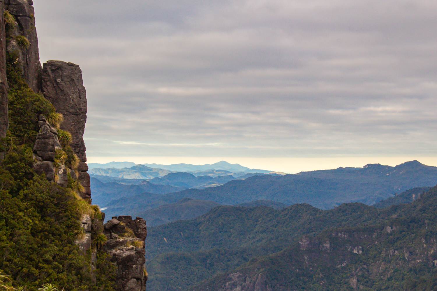
The Pinnacles in the Coromandel is a bucket-list day hike that’s earned its popularity. You’ll tackle a 14.2 km trail climbing 826 meters through dense forest, across swinging bridges, and up ladders, testing your legs but rewarding you with unforgettable views.
Get to the summit, and you’ll soak in sweeping panoramas over Coromandel Forest Park and the Waikato region. I caught a sunrise here, and it was magic but I can imagine that sunset would likely be just as spectacular. If you’re keen for an overnight adventure, you can book a spot at Pinnacles Hut to extend your time exploring this stunning spot.
This trek is a North Island classic for a reason but here we’re just skimming the surface–head over to the full post on the Pinnacles for all the details.
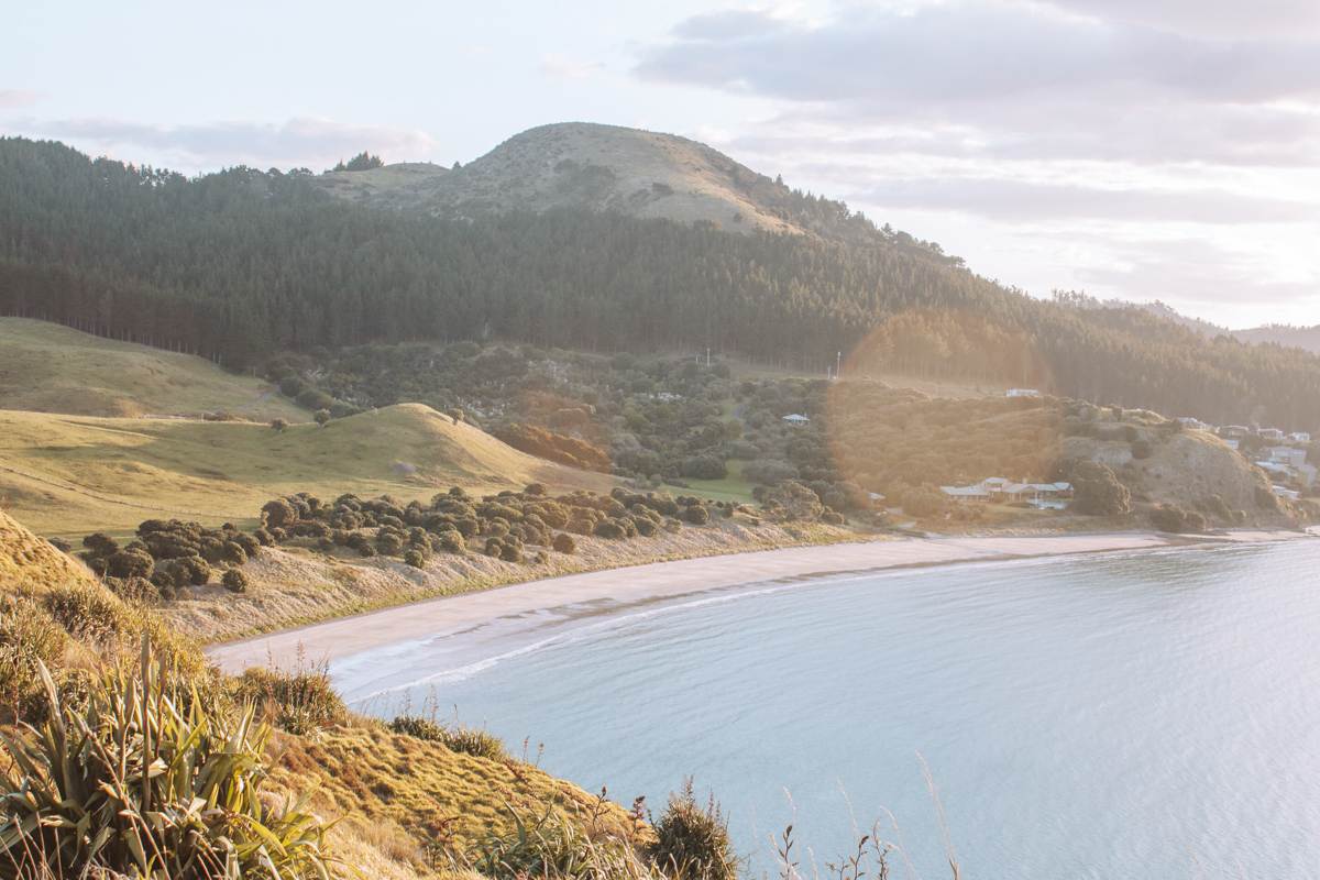
TĀWHARANUI POINT VIA NORTH AND SOUTH COAST TRAILS, AUCKLAND
Location: Auckland
Distance: 9 km | 5.6 miles
Elevation: 360 meters
Duration: 2 hours 30 minutes
Difficulty: Easy
Trail Type: Loop
Open: Year-round
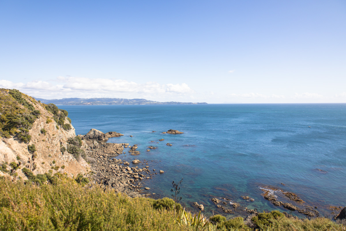
Searching for a coastal gem that’s still off the beaten path? You’ll find Tāwharanui Point in Auckland’s Tāwharanui Regional Park is a stunner. Surprisingly, this is just over an hour from the city, and the 9km loop combines golden beaches, rolling farmland, and native bush into one peaceful walk along the North and South Coast Trails.
You’ll have the coastline in view the entire way, with sightings of birdlife, grazing sheep, and wide-open landscapes. It’s also an easy trail with a few gentle hills, making it perfect for a more relaxed walk. For the best experience, go on a weekday or early morning, and pair your hike with a swim at Tāwharanui Beach for the ultimate day out.
Rather than cram it all in here, I’ve unpacked everything you need to know into this Tāwharanui Point post.
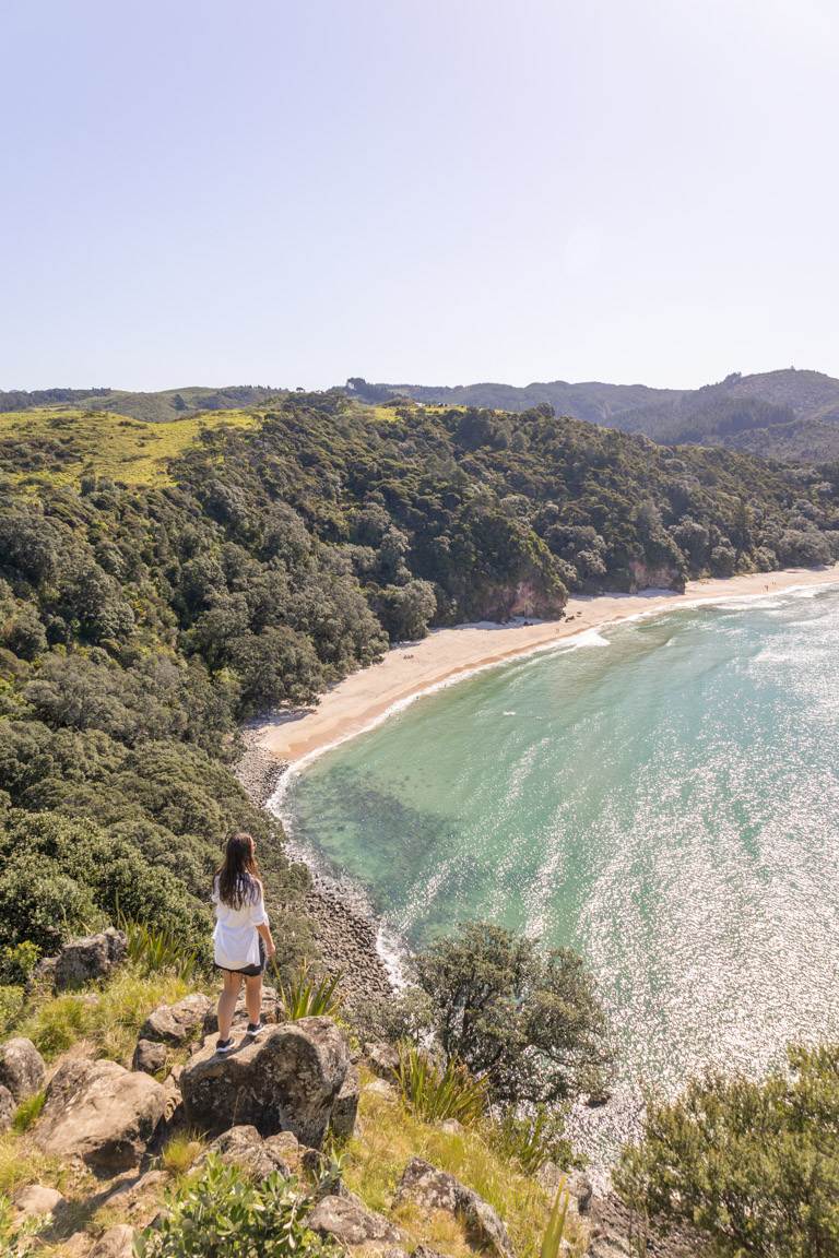
MOUNT MAUNGANUI SUMMIT TRACK, BAY OF PLENTY
Location: Bay of Plenty
Distance: 3.9 km | 2.4 miles
Elevation: 207m
Duration: 1 hour
Difficulty: Easy – Moderate
Trail Type: Loop
Open: Year-round
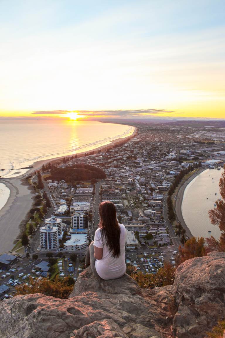
A Bay of Plenty icon, you’ll find the Mount Maunganui Summit Track is a short but sweet loop that’s loved by locals and visitors. The 3.9 km trail takes you along the ridgeline of the mountain, through shaded bush (depending on the trail you take) and open scrub, eventually climbing to a summit with unbeatable views of Tauranga Harbour, Matakana Island, and the Pacific Ocean.
Sunrise is a popular time, so expect company, but the views make it all worth it. Take the steep stairs up for a workout, then loop back via the gentler 4WD road for an easier descent. It’s perfect for a quick adventure before a pre-beach stroll or swim.
More details, take a look at my Mount Maunganui guide here.
OPITO BAY PA, COROMANDEL
Location: Coromandel
Distance: 2.7 km | 1.7 miles
Elevation: 120 meters
Duration: 1 hours
Difficulty: Easy
Trail Type: There-and-back
Open: Year-round
For a short walk packed with coastal views, you’ll love Opito Bay Pā in the Coromandel. This 2.7 km trail starts at the beach and climbs via a staircase to a grassy headland, which is a Māori pā site. Once at the top, you’ll then have an elevated view, stretching across to the Mercury Islands and the Pacific.
Pair this hike with a stroll along Opito Bay Beach and a visit to Crayfish Bay for a perfect summer day. I’d highly recommend sunrise here followed by a swim. It’s undoubtedly an easy, high-reward trail that doesn’t require much effort.
I’ve kept it short here, but if you’re planning something similar, my full write-up on Opito Bay Pa will come in handy.
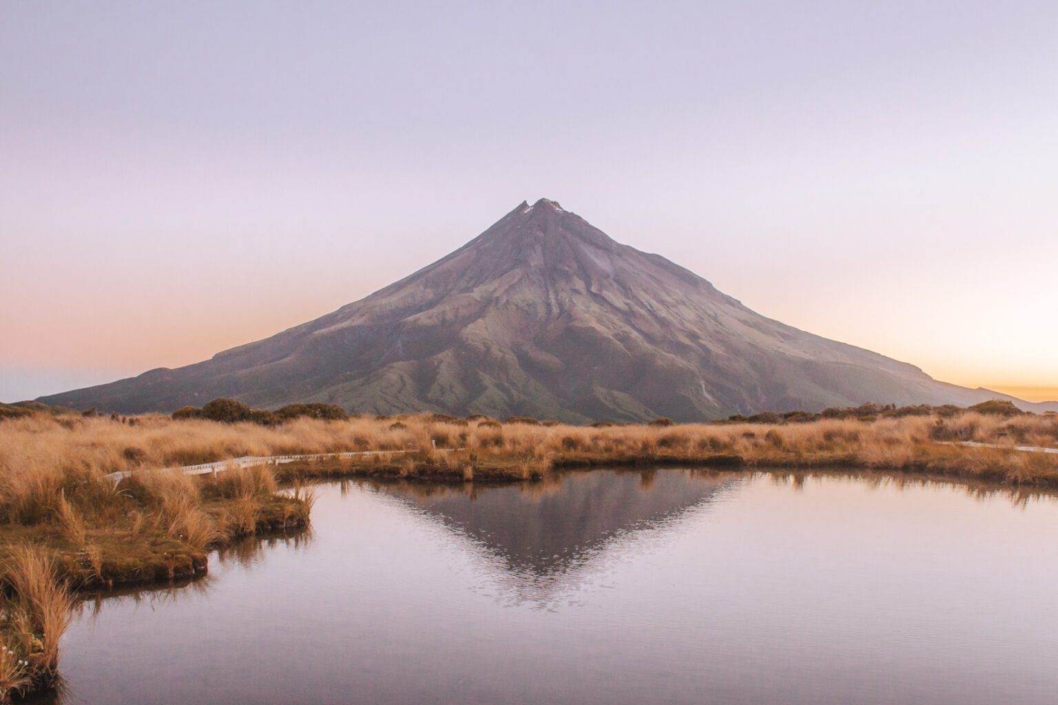
POUAKAI TARNS, TARANAKI
Location: Taranaki
Distance: 12.4 km | 7.7 miles
Elevation: 777m
Duration: 6 hours
Difficulty: Moderate
Trail Type: There-and-back
Open: Year-round but be wary as this track can become impassable in winter.
For one of the best hikes with a view in the North Island, Pouakai Tarns in Taranaki earns its spot with its incredible coastal scenery and iconic Mount Taranaki reflection. It’s surprisingly only 20 minutes from New Plymouth, with the Mangorei Track climbing through lush forest to the Pouakai Ranges. It’s definitely one of the most iconic views you can capture when travelling New Zealand.
I’d recommend either sunrise or sunset for this hike as it offers the most incredible and clearest reflections when the wind is calm. If you want to ensure a better chance at some more favourable weather consider staying at Pouakai Hut. This is a DOC Hut that’s located just a short walk from the tarns.
Love this bit? You’ll want to check out the full guide on the Pouakai Tarns here.
CAPE BRETT, NORTHLAND
Location: Northland
Distance: 30.3km | 18.8 miles
Elevation: 1791m
Duration: 11-12 hours (one night, two days)
Difficulty: Difficult
Trail Type: There-and-back
Open: Year-round
Ready for a serious coastal adventure? You’ll find the Cape Brett Track in the Bay of Islands is a challenging 30.3 km trek that delivers big, earning its place among the best hikes with a view in the North Island of New Zealand. Winding through native bush and along dramatic clifftops, it then ends at the iconic Cape Brett Lighthouse or, for overnight hikers, the Cape Brett DOC Hut.
Expect rugged terrain, steep climbs, and muddy patches, especially after rain. But the reward? Stunning views of jagged coastlines, lush forests, and endless ocean. This advanced hike requires a permit and hut bookings, and you’ll need to be well-prepared. However, if you don’t want to do the full hike, as a shorter option consider taking the water taxi to-and-from Deepwater Cove.
It’s definitely one of the toughest hikes if you’re travelling New Zealand but seriously unforgettable. If you’d like to know more, I’ve got everything covered in this full Cape Brett guide.
NEW CHUMS, COROMANDEL
Location: Coromandel
Distance: 5.1km | 3.1 miles
Elevation: 112m
Duration: 30 minutes
Difficulty: Easy
Trail Type: There-and-back
Open: Year-round
Tucked away on the Coromandel Peninsula, you’ll discover New Chums. Starting at Whangapoua Beach, this 5.1 km trail follows a rocky path and bush track to a pristine, undeveloped beach with golden sand and crystal blue water. No roads, no cafes so it feels like a hidden paradise.
The walk is easy but can be slippery and tidal, so check conditions. As a bonus side mission, take the steep side trail to a lookout with incredible views across the beach and ocean. Just make sure you have sturdy shoes. This is a summer must-do for beach lovers and one of my favourite best hikes with a view, so if you’d like some more details check out my New Chums guide.
SUMMARY
In this guide, we’ve explored the best hikes with a view in North Island, New Zealand, perfect for hikers seeking some outdoor adventures and those who just love a good view. From the coastal cliffs of Cape Brett to the iconic Mount Taranaki reflection at Pouakai Tarns, these trails offer unforgettable vistas and practical tips to make your hike a breeze. Whether you’re tackling a quick city loop like Mount Eden or a multi-day challenge like Cape Brett, you’re set for an epic North Island, New Zealand adventure.
Want more hiking inspiration? Check out my hiking guides to travel New Zealand’s top outdoor destinations or browse my comprehensive travel guides for more adventures worldwide.
FAQ's
What are the best times of year to hike in the North Island of New Zealand?
Most trails in this guide are open year-round, but spring (September–November) and autumn (March–May) offer mild weather and fewer crowds. Summer is great for coastal hikes like New Chums, but make sure to pack sun protection. Winter can make some tracks, like Pouakai Tarns, impassable, so always check conditions on the Department of Conservation (DOC) website.
Are these hikes suitable for beginners?
Yes, many of these best hikes with a view are beginner-friendly! Mount Eden, Papamoa Hills, Opito Bay Pā, St Pauls Rock, and Te Henga Walkway are rated easy, also with short distances and manageable elevation. Omanawa Falls and Tāwharanui Point are also great for novices, though Dukes Nose and Cape Brett are much more challenging and should only be attempted if you feel you are capable. Always check trail conditions and bring water and sun protection.
Do any of these hikes require permits or bookings?
Cape Brett requires a permit and DOC hut bookings for overnight stays but all other hikes in this guide are permit-free. Just make sure to do your research for any New Zealand hikes prior to setting out. Also check for any temporary closures, especially for Te Henga Walkway, which is part of the partially closed Hillary Trail.
What should I pack for these hikes?
Essentials include sturdy shoes, water, snacks, sunscreen, and a hat for exposed trails like Papamoa Hills. For early starts (e.g., Dukes Nose), a headlamp is a must. Layered clothing is key for windy or rainy conditions on trails. Even though some of these hikes are the best for incredible views, you need to make sure you’re prepared.
Can I combine these hikes with other activities?
Absolutely! Pair Mount Tauhara with Taupō’s Huka Falls or Māori Rock Carvings, Tāwharanui with a beach swim, or Bell Rock with a Hawke’s Bay winery visit. Opito Bay Pā is perfect with a stroll to Crayfish Bay, and Mount Maunganui is ideal before a beach day. I love pairing these hikes with other activities, it’s the best way to see more of the region!
How can I capture the perfect travel aesthetic on these hikes?
These trails are made for that dreamy New Zealand vibe so aim for golden hour (sunrise or sunset) on hikes like Pouakai Tarns or Mount Donald McLean for reflections and warm light. These times will also help you avoid the crowds. Also, if you have a drone, make sure you are keeping to rules and regulations but these can get some incredible Instagram shots. The lush native bush and ocean backdrops you absolutely can’t get sick of so no matter where you look on these hikes, you’ll be fulfilling that dreamy travel aesthetic.
Are there camping options near these hikes?
Yes! There are also so many camping sites that you can take advantage of. The app Rankers, alongside the DOC website have plenty of options but there are also many locally owned campsites too. If you’re interested in camping in a particular spot, type in campsites into Google Maps, it’ll give you a really good idea on what’s around. Also, it’s not exactly camping but you will find many DOC Hut options – cue Pinnacles Hut, Cape Brett DOC Hut and Pouakai Hut (which are all bookable via the DOC website) are great places to stay too. Make sure no matter where you stay, always follow Leave No Trace principles and book ahead in peak season.
Which hikes should I add to my summer bucket list?
To be honest, all of these best hikes with a view are perfect for your summer bucket list. But, for sun-soaked summer magic, prioritise coastal gems like New Chums Beach (pristine sands and swims), Opito Bay Pā (sunrise followed by a dip), Mount Maunganui Summit Track (pre-beach workout), and Tāwharanui Point (loop with a beach picnic). These easy-to-moderate trails offer turquoise waters and golden-hour glows, perfect for a New Zealand summer day.
What makes these hikes essential for a New Zealand travel itinerary?
Overall, they showcase the North Island’s diversity–from volcanic craters (Mount Eden) to ancient pā sites (Opito Bay Pā) and dramatic coastlines (Cape Brett), these best hikes with a view are a perfect addition to a New Zealand travel itinerary. These best hikes with a view blend adventure, culture, and nature, making them a non-negotiable for any NZ trip. Additionally, they’re accessible yet rewarding, fitting solo travellers, families, or those doing a road trip.
Quick Summary
For those looking for a quick summary of the best hikes with a view in the North Island, New Zealand, these are the hikes and info that this blog post has covered:
- Bell Rock, Hawke’s Bay: 7.2 km, medium, loop, panoramic peninsula views.
- Papamoa Hills, Bay of Plenty: 3.7 km, easy, 360 degree ocean and Mount Maunganui views.
- Karamatura to Mount Donald McLean, Auckland: 11.3 km, medium, located in the Waitākere Ranges and has city skyline and black sand views.
- Dukes Nose Lookout, Northland: 10.8 km, moderate, 360° Bay of Islands views.
- Mount Tauhara, Taupō: 7.3 km, medium, Lake Taupō and Ruapehu vistas.
- The Pinnacles, Coromandel: 14.2 km, medium, Coromandel Forest Park panoramas.
- Mount Eden, Auckland: 2.1 km, easy, city skyline and harbour views.
- Tāwharanui Point, Auckland: 9 km, easy, coastal loop with nearby beaches and birdlife.
- Cape Brett, Northland: 30.3 km, difficult, dramatic clifftop ocean views.
- Opito Bay Pā, Coromandel: 2.7 km, easy, Māori pā site with Pacific views.
- Pouakai Tarns, Taranaki: 12.4 km, moderate, Mount Taranaki reflection.
- Mount Maunganui, Bay of Plenty: 3.9 km, easy–moderate with Tauranga Harbour vistas.
- New Chums, Coromandel: 5.1 km, easy, pristine beach and lookout views.
- Omanawa Falls, Bay of Plenty: 2.7 km, easy–moderate, waterfall lookouts.
- St Pauls Rock, Northland: 1.1 km, easy, Whangaroa Harbour vistas.
- Te Henga Walkway, Auckland: 3.7 km, easy, Waitākere coastal viewpoints.
Top Travel Resources to Plan Your Next Trip
Finding the Best Flights
Skyscanner: A great platform for comparing flight prices across airlines and routes.
Omio: Perfect for comparing not just flights but also trains and buses, especially for European travel.
Booking Your Stay
Hostelworld: Ideal for those specifically looking to budget on their travels and seeking hostels, guesthouses, or shared accommodations.
Booking.com: With a massive selection of hotels, apartments, and unique stays, this platform additionally has deals for frequent travellers.
Discovering Amazing Activities
GetYourGuide: My go-to for booking tours, tickets, and activities worldwide.
Everything New Zealand: A must for anyone traveling to New Zealand. This platform offers a curated selection of tours, activities, and adventures to make your Kiwi trip epic.
G Adventures: For small-group tours with a focus on sustainable and authentic travel, G Adventures is unbeatable.
Capturing Your Memories
MILK Books: Create stunning photo books to preserve your travel memories. Expect high-quality prints and customisable designs.
These links are affiliate links. If you book through them, I earn a small commission at no extra cost to you. Your support helps me keep sharing guides like this. Thanks for helping fuel the next adventure!