The Kohi Point Walkway is one of the East Coast’s best coastal walks, blending bush, cliffs, and big Pacific views in one stunning trail.
It starts right in Whakatāne, my hometown, and was one of my favourites for 2025.
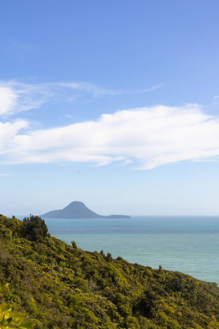
Across the walk through native bush are multiple viewpoints, with Whale Island (Moutohora) front and centre. On clear days, you might even glimpse Whakaari/White Island in the distance.
It’s a walk that delivers in spades. Scenic without being busy and flexible enough to suit half a day or a full adventure. For everything you need to know, below is an in-depth guide to help you plan.
This post may contain affiliate links. Your purchase through these links supports me with a commission, at no added expense to you.
KEY TAKEAWAYS
- A complete guide to the Kohi Point Walkway in Whakatāne – everything from trail details and tide tips to parking, best times, photography, solo safety, and nearby adventures in the Bay of Plenty.
- If you’re after an underrated coastal gem that’s rewarding without being overcrowded, this trail is spot-on. It suits locals, visitors, solo hikers, or anyone wanting epic views, native bush, and the option to finish with a beach day.
- Practical advice on getting there, timing tides for the beach section, avoiding crowds, capturing those golden-hour shots, accommodation options, and other day trips to make the most of your time in the region.

KOHI POINT TRAIL LOCATION
The Kohi Point Walkway is located in Whakatāne, linking the township with Ōhope Beach on the East Coast of New Zealand’s North Island.
HOW TO GET TO KOHI POINT WALKWAY
Kohi Point Walkway is easy to reach thanks to its location right next to Whakatāne township.
If you’re travelling from Auckland, expect the drive to take roughly 4 hours, depending on traffic and where you stop along the way. From Rotorua, the trip usually takes around 1 hour 30 minutes, making it a very doable day trip or overnight escape. From Taupō, allow just over 2 hours, and additionally, from Wellington, you’re looking at about 7-8 hours.
Once you arrive in Whakatāne, the start of the walk sits just a few minutes from town. You’ll head toward the eastern edge of the township, following Hillcrest Road until you reach the small carpark on Seaview Road.
Parking tips
The small carpark on Seaview Road (just off of Hillcrest Road) is the ideal place to park. It fits about 5 cars, so arrive early if you’re driving. If it’s full, there is some street parking on Waiewe Street, though it’s unofficial and on the curb. Worst case? Park in town at the end of George Street and Clifton Road and walk up Hillcrest – it adds a bit of extra leg stretch but gets you right into the action.
You can also start from the Ōhope Beach side for a reverse experience.


KEY INSIGHTS FOR WALKING KOHI POINT WALKWAY
Distance: 11.6 km | 7.2 miles
Elevation: 550 meters
Duration: 4–5 hours
Difficulty: Medium
Trail Type: There-and-back
Open: Year-round
One thing I love about the Kohi Point Walkway is that you can shape it around how you want your day to feel – out and back, or one way with a beach finish. Either way, you start gently from the carpark, following Seaview Road before stepping onto the track and into Kohi Point Scenic Reserve.
Once in the bush, you’ll start to gain some elevation via multiple sets of stairs, tucked into shaded forest. It’s cool here, calm, and a nice place to settle into the walk.
A couple of kilometres in, you’ll reach the turnoff for Kohi Point Lookout Road. It’s a small detour, but a good one. The extra steps lead to wide, open views across Whakatāne and Whale Island.
From there, the track continues along the coastline, opening up more as you go. There are viewpoints scattered along the way, but the best ones come once you reach Kohi Point. Here, the land drops away, and the Pacific stretches out in front of you.
One of the things that makes this walk so appealing is its flexibility. You can return the way you came, or continue one way towards Ōhope Beach if you’ve planned a car shuffle. The one-way option works especially well if you want to finish your day on the sand, swimming, resting, or finding lunch by the water.
If you do continue past Kohi Point, the trail eventually drops into Ōtarawairere Bay and along the beach. This part only works around low tide, so checking tide times is essential. You can also flip the experience entirely and start from the Ōhope side instead of Whakatāne.


BEST TIME TO VISIT
Early morning really is the sweet spot for this walk, especially if you want it to feel quiet and unrushed. I started around 7:30am and only passed a handful of people on the way out.
Because the track sits so close to town, it naturally gets busier as the morning goes on. By mid-morning, especially on weekends or in summer, you can expect it to be much busier.
If you’re planning to walk the full track or go one way to Ōhope, it’s also worth timing your walk around the tides. The beach section near Ōtarawairere Bay only works at low tide, so planning around this can matter more than the clock.
HOW CROWDED IS IT
Crowd levels really depend on when you start.
Early mornings feel calm and spacious. Late mornings feel busier, especially near the Whakatāne end of the track. When I walked it at 7:30am, the trail felt almost empty. When I came back around 10am, I noticed a lot more people heading out.
The good thing is that the longer sections of the track naturally spread people out, so it rarely feels packed. It just shifts from quiet to lively as the day goes on.
OTHER POSTS YOU MIGHT LIKE
IS IT SAFE TO WALK SOLO
Absolutely. I did the Kohi Point Walkway solo and felt completely comfortable the entire time.
The track is well formed, easy to follow, and close enough to town that I never felt isolated. That said, it’s still a coastal track with cliffs and changing conditions, so the usual solo travel habits matter – let someone know where you’re going and when you expect to be back. Carry water and snacks. Check the weather and tide times.
PHOTOGRAPHING KOHI POINT WALKWAY
The Kohi Point Walkway is a really satisfying walk to photograph because it packs a lot of variety into a short distance. You move from shaded bush and forest into open cliff-top views and big skies over the Pacific, which makes it feel like several different landscapes stitched into one walk.
The Kohi Point Lookout and the viewpoints along the headland are especially beautiful in the early morning or late afternoon. When I headed out in the morning, the softer light brought out the blues in the ocean and kept the cliffs from looking too harsh. By the time I walked back, the light was stronger and had a bit more contrast.
If photography is one of your main reasons for walking this track, those earlier or later hours really are your best bet. The softer light adds depth, colour, and mood in a way the midday sun just doesn’t.

ACCOMMODATION
Because the walk sits right next to Whakatāne, you’ll find plenty of accommodation options close by.
Staying in town works well if you want easy access to cafes, restaurants, and shops, or if Kohi Point is just one part of a bigger Bay of Plenty trip.
If you’re finishing the walk at Ōhope, staying beachfront is a lovely way to end the day. Slower mornings, swims before breakfast, and that relaxed coastal feeling make it a great contrast to town. There are plenty of options on both AirBnB and Booking.com.
CAN YOU CAMP AT KOHI POINT WALKWAY
There’s no camping available at the Whakatāne trailhead of Kohi Point Walkway.
However, if you plan to walk one way and finish at Ōhope Beach, you’ll find plenty of camping options nearby. Holiday parks in the area offer powered and unpowered sites, cabins, and even glamping setups, depending on how simple or comfortable you want your stay to be.
Ending a coastal walk and falling asleep near the ocean sounds pretty great.

OTHER ACTIVITIES NEARBY
If you’re basing yourself in Whakatāne or Ōhope, the Bay of Plenty region has plenty of great day trips to keep the adventure going. Here are some favourites that pair perfectly with the Kohi Point Walkway – all reachable by car:
Redwoods (Whakarewarewa Forest)
About 1–1.5 hours drive to Rotorua. Explore through towering Californian redwoods in this magical forest – think easy walking trails, and that fresh pine scent. It’s a total contrast to the coastal walk, super family-friendly, and free entry (unless you plan to do the treetop walk – this will cost you a little extra).
Tarawera Falls
Roughly 1 hour from Whakatāne. This one’s a gem – a short, flat, easy track through shady bush leads to a dramatic waterfall bursting straight out of the cliff face. Feels off-the-beaten-track and surprising in the best way. Grab a free permit from the Kawerau i-SITE first (private land), and you’re set.
Papamoa Hills
Around 45–60 minutes away. Climb steadily through open farmland to epic summit views over the Bay of Plenty, Mount Maunganui, and the Pacific. Wide, safe paths – just bring sun protection and water since it’s exposed. Sunrise here is stunning if you’re up for an early start.
Pukehina Beach
Just a 30–40 minute drive west. A long, quiet stretch of unpolished coast – perfect for chilling with fresh air, walks along the sand, and minimal crowds. Great if you want low-key beach time after your hike. Just make sure you stop in at Monty’s for a coffee.
Mount Maunganui
About 1 hour drive. “The Mount” lives up to the hype. Take a stroll on the easy base track for ocean views everywhere, or tackle the short, steep summit for more panoramas. Pair it with a swim, ice cream, or lunch in town – it’s a classic, and busy but worth it.
Blue Springs (Putāruru)
Around 1.5–2 hours away. Follow the flat, easy Te Waihou Walkway to see water so crystal clear it supplies 70% of NZ’s bottled water. Stunning turquoise views, native bush, and super accessible for everyone (no swimming anymore to keep it pure). However, just make sure to early or mid-week to dodge the crowds.
OTHER PINS YOU MIGHT LIKE

CONCLUSION
The Kohi Point Walkway is one of those trails that sticks with you. It’s a perfect blend of New Zealand coast, native bush, and those wide-open Pacific views. Starting right in my hometown of Whakatāne, it was hands-down one of my top picks for 2025.
Whether you’re after a quick out-and-back for the views or a full one-way adventure ending with toes in the sand at Ōhope. It’s the kind of walk that reminds you why we love getting outdoors in Aotearoa: fresh air, birdsong, history underfoot, and those big-sky moments.
If you’re after more walks like this, check out our other New Zealand travel guides for trails, photography spots, and outdoor escapes across the country. To explore all our locations and ideas, head over to our international destination guides.
FAQs
How long is the bird walk in Whakatāne?
The “Bird Walk” refers to the section through Mokorua Bush Scenic Reserve on the Ngā Tapuwae o Toi Trail. This part takes about 1–1.5 hours and is roughly 2–3km.
What is the most beautiful walk in New Zealand?
Beauty is completely subjective, but the Milford Track often tops lists as one of the most stunning (and famous) – known for its dramatic Fiordland scenery, waterfalls, valleys, and lakes. Other contenders include the Routeburn Track for alpine views or the Abel Tasman Coastal Track for beaches and golden sands. The Kohi Point Walkway holds its own for coastal vibes closer to home!
What is the longest walking trail in New Zealand?
Te Araroa (The Long Pathway) is the longest – a massive 3,000 km trail running the full length of the North and South Islands from Cape Reinga to Bluff. It takes 3–6 months and mixes tracks, roads, and beaches. For shorter but still epic, the Heaphy Track (one of the Great Walks) is the longest at around 75km.
How far is the TOIS track?
Ngā Tapuwae o Toi (Footsteps of Toi) is a 16–17 km loop trail connecting Whakatāne to Ōhope Beach and back. It features varied terrain (forest, sand, rocks, grass) with frequent ups and downs. Named after Māori chieftain Toi, whose ancient pā, Kapu-te-Rangi (Pā of Gentle Breezes), overlooks Whakatāne. The full loop hosts the annual Toi’s Challenge (18 km race/walk).
What is the hardest walking track in New Zealand?
The Dusky Track in Fiordland is often called the toughest – a 90 km, 7–8 day slog through rugged, muddy terrain, river crossings, and sandflies (no Great Walk luxuries!). Among the Great Walks, the Heaphy Track or Hump Ridge Track rank as more challenging due to length, elevation, and exposure.
LIKE THIS POST? PIN IT HERE
Top Travel Resources to Plan Your Next Trip
Finding the Best Flights
Skyscanner: A great platform for comparing flight prices across airlines and routes.
Omio: Perfect for comparing not just flights but also trains and buses, especially for European travel.
Booking Your Stay
Hostelworld: Ideal for those specifically looking to budget on their travels and seeking hostels, guesthouses, or shared accommodations.
Booking.com: With a massive selection of hotels, apartments, and unique stays, this platform additionally has deals for frequent travellers.
Trivago: A powerful search engine for comparing hotel prices across multiple booking sites to find the best deals for your stay.
Renting a Car
Europcar: Offers a wide range of vehicles for hire in New Zealand and worldwide, perfect for exploring at your own pace.
AVIS: A trusted car rental service with a variety of vehicles and locations, ideal for seamless travel adventures.
Travel Essentials & Gear
Amazon.com: Your one-stop shop for travel gear, gadgets, packing essentials, and last-minute trip must-haves.
Discovering Amazing Activities
GetYourGuide: My go-to for booking tours, tickets, and activities in New Zealand and worldwide.
Everything New Zealand: A must for anyone traveling to New Zealand. This platform offers a curated selection of tours, activities, and adventures to make your Kiwi trip epic.
G Adventures: For small-group tours with a focus on sustainable and authentic travel, G Adventures is unbeatable.
Capturing Your Memories
MILK Books: Create stunning photo books to preserve your travel memories. Expect high-quality prints and customisable designs.
These links are affiliate links. If you book through them, I earn a small commission at no extra cost to you. Your support helps me keep sharing guides like this. Thanks for helping fuel the next adventure!
LATEST FROM THE BLOG
A SUMMARY OF KOHI POINT WALKWAY
- Trail Overview: Medium 11.6 km (7.2 miles) out-and-back coastal walk in Whakatāne, Bay of Plenty. Blending native bush, cliff-top views, historic pā sites, and Pacific panoramas with Whale Island (Moutohora) as the star. Flexible for one-way to Ōhope Beach finish.
- Key Stats: Distance: 11.6 km return (7 km one way to Ōhope). Elevation: 550 m. Duration: 4–5 hours. Difficulty: Medium (stairs, steady climbs, some exposure). Open year-round; Free entry.
- Best For: Coastal lovers, photographers, solo hikers, locals/visitors wanting epic views, native birdsong, and the option to end with a beach day at Ōhope. Great for half-day or full adventure.
- Access & Logistics: Starts near Whakatāne township (small carpark on Seaview Road, 5 spots – arrive early). 4 hrs drive from Auckland, 1.5 hrs from Rotorua; can also start from Ōhope side. Check Metservice for Whakatāne tides. Otarawairere Bay section impassable at high tide.
- Tips: Go early morning for quieter vibes, golden light photos, and fewer crowds. Carry water/snacks. Tell someone your plans if solo and pair with nearby day trips like Papamoa Hills or Mount Maunganui.
- Nearby Attractions: Ōhope Beach (swim/relax), Tarawera Falls (short waterfall walk), Redwoods Forest (towering trees in Rotorua), Blue Springs (crystal-clear water), Pukehina Beach (quiet coast).
- Safety & Practicality: Well-formed track, solo-safe near town. Check weather/tides/DOC or council for any slips/closures (some sections have had issues). No camping at trailhead, but plenty at Ōhope holiday parks. Download AllTrails or grab local maps for details.