Opito Bay Pā in the Coromandel is one of those quiet, and spectacular places that easily flies under the radar.
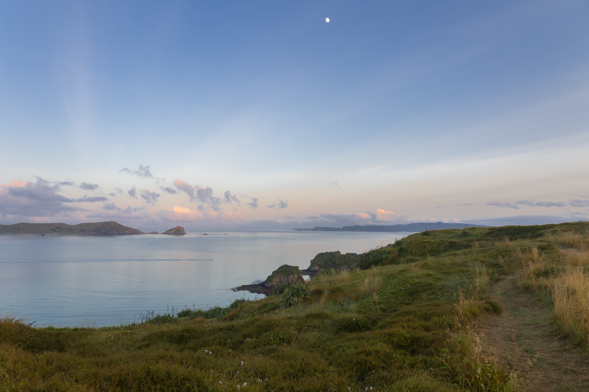
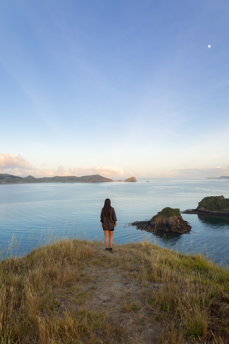
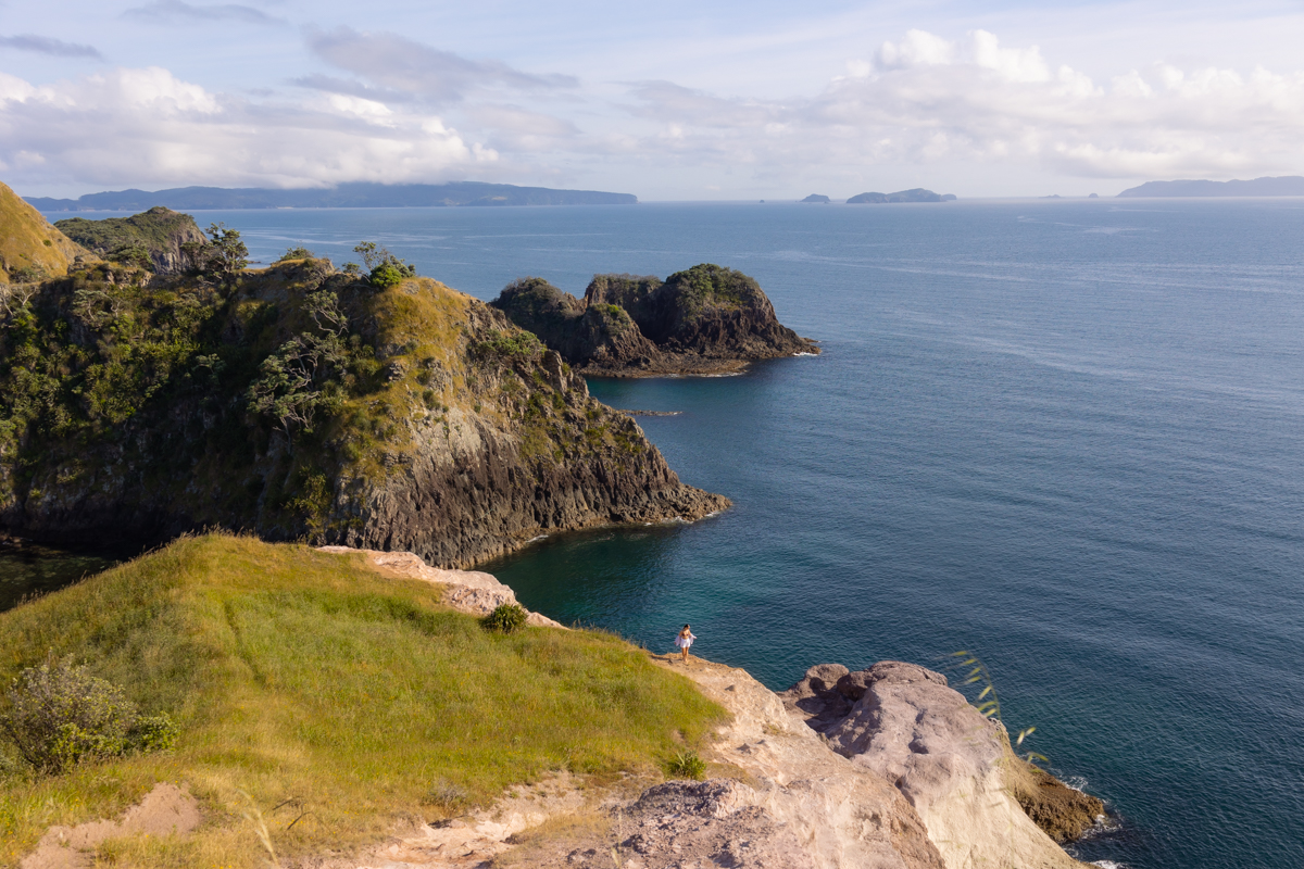
Perched above the eastern end of Opito Bay, this coastal headland is home to an ancient Māori pā, once used as a defensive settlement. It also boasts sweeping views across the Pacific Ocean, Opito Bay, and the Mercury Islands.
If you’re after a peaceful Coromandel experience with epic scenery and very few people around, Opito Bay Pā should be high on your list.
Below, I’ll walk you through everything you need to know – from how to get there to the best time to visit and what else to see nearby.
Please note: Te Reo Māori is our native language in New Zealand. When pā is mentioned, this translates to English as a village or settlement, often indicating hill forts – fortified settlements with palisades or defensive structures. Pā in this instance is referring to Opito Bay headland.
This post may contain affiliate links, which means I’ll receive a commission if you purchase through my link, at no extra cost to you.
KEY TAKEAWAYS
- This guide explores Opito Bay Pā, a serene historic Māori headland lookout perched above one of the Coromandel’s quietest bays. It offers sweeping ocean views, ancient pā remnants, and solitude away from other crowded and tourist spots in the area.
- It’s worth your time if you’re craving an authentic, peaceful Coromandel experience with epic photography opportunities, cultural history, and easy access to hidden beaches like Crayfish Bay.
- You’ll get everything for a seamless visit: step-by-step directions, best times for sunrise/sunset magic, photography advice, tips on nearby eats and stays, and bonus activities to fill your day in this underrated corner of the peninsula.
OPITO BAY PĀ LOCATION
Opito Bay Pā sits on the southern edge of the Kūaotunu Peninsula, along the Coromandel’s east coast. The nearby settlement of Kūaotunu is a relaxed coastal village and makes a great base if you’re planning to explore the northern Coromandel region.
This part of the peninsula feels far removed from the busier tourist hubs, which is exactly why places like Opito Bay still feel so untouched.
HOW TO GET TO OPITO BAY PĀ
Opito Bay is around a two hour drive from Thames, and just over three hours from Auckland. If you’re coming from Whitianga (the closest main town) allow roughly 40 minutes.
The drive itself is part of the experience. You’ll follow the Pacific Coast Highway (Kūaotunu Wharekaho Road), winding through hills and farmland before reaching Kūaotunu township. From there, turn onto Black Jack Road and continue past Luke’s Kitchen.
The final stretch includes long gravel sections, so take it slow. The road is narrow in places, but trust me, the coastal views more than make up for it.
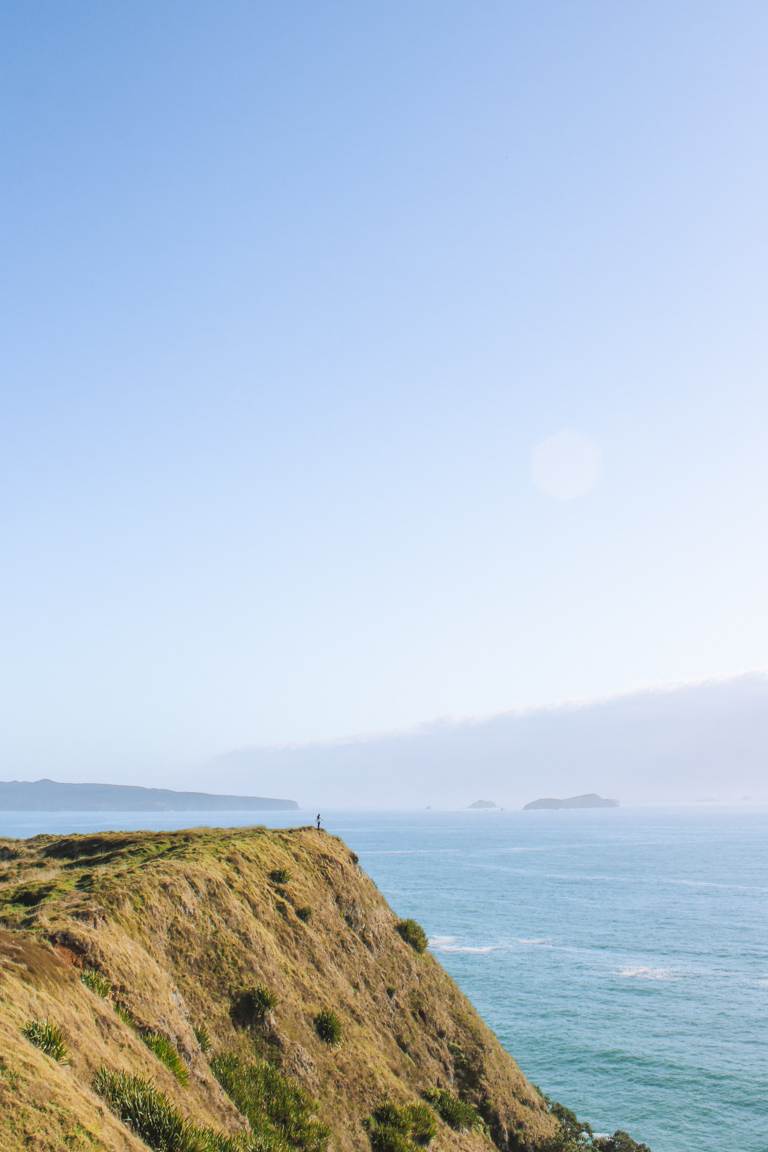
You’ll want to aim for Opito Bay Beach, where the track to the pā begins at the eastern end. This is about a 10 minute walk along the beach to the base, and then up 196 stairs. It sounds like a lot, but trust me, it’s worth it. It’s also best to time your visit for low tide as it’ll make your beach walk a little easier in order to get to the far end.
Parking tips
The best place to park is at the end of Opito Bay Road, just before it turns into Moore Crescent. There’s a large grassy area here that’s commonly used by visitors.
For the exact location, click here for Google Maps.

BEST TIME TO VISIT OPITO BAY PĀ
There’s really no bad time to visit Opito Bay Pā. The views are impressive any time of day and year.
That said, sunrise and sunset are next level. Early morning brings calm seas, soft light, and usually complete solitude. Sunset offers warm tones, long shadows, and a golden glow across the Mercury Islands.
If you’re into photography, these times are worth setting the alarm for.
HOW CROWDED IS IT
Because Opito Bay is fairly remote, this spot stays beautifully quiet. Most of the time you’ll either have it completely to yourself or be sharing it with just a handful of others.
On my sunrise visits, I’ve often been the only person there. It’s usually not until well after the sun is up that a few more people start arriving.


IS IT SAFE TO VISIT OPITO BAY PĀ SOLO
Yes, I’ve visited Opito Bay multiple times, two of those solo, and always felt comfortable.
The track is short, well-defined, and easy to follow. But, as always, let someone know where you’re going, keep an eye on weather conditions, and avoid heading up in strong winds or heavy rain.
PHOTOGRAPHING OPITO BAY PĀ
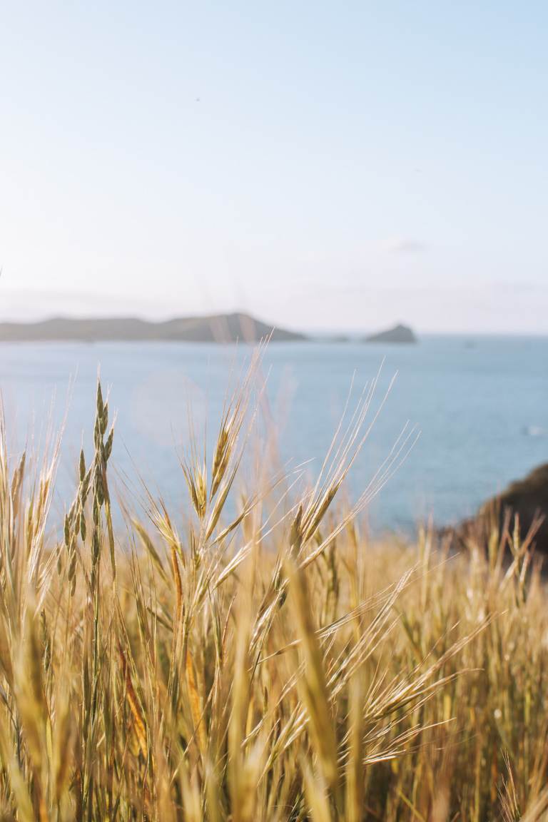
Photographing Opito Bay Pā and its surroundings are a dream. From the top, you get coastal views, turquoise water below, the curve of Opito Bay, and the Mercury Islands in the distance.
Because the headland is largely exposed, light makes a huge difference. Early morning and late afternoon are ideal, when the sun is lower and the contrast is softer. Midday light can be quite harsh, especially in summer. Sunrise is definitely my favourite time here as you’ll (ideally) have the entire headland to yourself. So you can get creative, and have plenty of space to do so.
ACCOMMODATION NEAR OPITO BAY PĀ
There are plenty of accommodation options around Opito Bay and Kūaotunu, ranging from holiday homes to beachfront stays. Airbnb and booking.com are usually the easiest places to start if you’re after something nearby.
For campers, Kuaotunu Campground is the closest official campsite, located about 20 minutes away. It’s well-maintained, and a great base for exploring this side of the peninsula.
If you’re travelling in a campervan, there are also several freedom camping spots in the wider area. Apps like CamperMate and Rankers are handy for finding up-to-date locations and checking local rules.


OTHER ACTIVITIES NEARBY
Crayfish Bay
Just around the corner from Opito Bay Pā is Crayfish Bay – a small, secluded cove with crystal-clear water and pale stone shores.
Surrounded by cliffs, it’s popular for swimming, cliff jumping, and lazy afternoons on the rocks. The beach itself is compact and covered pebbles, but there’s plenty of space along the cliffs to spread out and enjoy the view.
To get there, walk along Opito Bay Beach until you see a white post with a narrow trail heading to the right. Follow this across farmland for about five minutes and you’ll walk straight into the bay.
Lukes Kitchen
If you’re passing through Kūaotunu, a stop at Luke’s Kitchen is basically mandatory.
This laid-back coastal spot is known for its wood-fired pizzas, fresh seafood, and relaxed summer vibe. They often host live music, making it a perfect lunch or dinner stop after a day of exploring.
Luke’s Kitchen is open seasonally, so it’s best to check their current hours and menu online before you go.
Right next door is a small local store too, ideal for grabbing a cold drink or ice cream for the road.
Ōtama Beach
You’ll pass Ōtama Beach on the way to Opito Bay, and it’s well worth pulling over for.
This long, open beach stretches for around two kilometres and is backed by pōhutukawa trees. The Otama River meets the sea here, making it a great spot for swimming, relaxing, or setting up a picnic in the shade.
Sunset is especially beautiful, and if you’re feeling adventurous, check out the rope swing tucked away at the far right end of the beach.
Waiau Kauri Grove
A little further inland, Waiau Kauri Grove is an easy pit-stop if you’re driving via the 309 Road.
This short loop walk takes about 30 minutes and winds through native forest on boardwalks and gentle tracks. Along the way, you’ll come face-to-face with towering kauri trees estimated to be between 600 and 800 years old.
It’s usually quiet, easy to access, and a great way to experience one of New Zealand’s most iconic tree species up close.
New Chums Beach
New Chums Beach is one of the Coromandel’s most famous beaches, and for good reason.
The only way in is on foot, via a well-marked track that takes about 30 minutes. The walk crosses sand, bush, and a few rocky sections with coastal views along the way.
At the end, you’ll find a completely undeveloped bay with white sand, clear water, and native forest behind it. For an elevated view, continue up to the lookout above the beach, just make sure you’re wearing decent shoes.
Matarangi Bluff Loop via Rings Beach
If you’re keen on a longer walk, the Matarangi Bluff Loop is a solid option.
This 7.1km loop delivers a mix of bush tracks, coastal views, and beach access. The trail offers wide views over Matarangi, Rings Beach, Kūaotunu, and the surrounding coastline.
Starting from Bluff Road in Matarangi and walking anti-clockwise gives you the best viewpoints early on, finishing with a descent to Rings Beach, perfect for a post-hike swim.
I found this track on AllTrails, so you can check it out here for more details.
CONCLUSION
Opito Bay Pā is one of those places that quietly steals the show. It’s easy to access, rich in history (check out more in depth information here), and delivers some of the best coastal views in the Coromandel, without the crowds.
Whether you’re visiting for photography, a sunrise walk, or simply to experience a more peaceful side of the peninsula, it’s well worth the detour.
If you’re after more incredible spots like this, check out our other New Zealand travel guides for lookouts, and outdoor escapes across the country. To explore all of our locations, head over to our international destination guides.
FAQs
Are there any shops in Opito Bay?
No shops, cafes, or services exist directly in Opito Bay. It’s a peaceful, undeveloped residential area with holiday homes. Stock up on essentials (food, water, snacks, sunscreen) in Kūaotunu at the general store or in Whitianga before arriving.
Is Opito Bay a protected area?
Yes, partially. The Opito Bay Pā historic site is a DOC managed historic reserve. The coastal environment and nearby areas (like Mercury Islands) are ecologically sensitive. No full marine reserve exists in the bay itself, but follow rahui (temporary restrictions) if in place for fishing/scallops and check DOC for current rules.
Is Opito Bay good for surfing?
Opito Bay isn’t a great surfing spot as it’s sheltered, so waves are usually small and inconsistent (knee-to-waist high on good swells, best for longboards or beginners). It’s more popular for calm swimming, snorkelling, and boogie boarding. Nearby Rings Beach or Kūaotunu often have better surf.
How crowded is Opito Bay Pā?
Very low crowds due to the remote gravel road access. Many visitors report having the beach and pā to themselves, especially at sunrise/sunset or early mornings. It gets busier mid-morning in peak summer, but never feels overrun like Hot Water Beach or Cathedral Cove.
Are dogs allowed?
No, dogs are not permitted on the pā site or Crayfish Bay track to protect wildlife/archaeology.
Is it safe for swimming/snorkelling, and are there sharks in Opito Bay?
Crystal-clear water is excellent for swimming and snorkelling (especially Crayfish Bay rock pools). Gentle waves suit families. Bronze whaler sharks are occasionally spotted in Coromandel waters (warmer months), but incidents are rare. Just make sure to avoid dawn/dusk swims if concerned, and check local reports.
When are the best tides in Opito Bay?
Low tide is ideal: easier beach walking to stairs, exploring Crayfish Bay, and rocky west end. High tide can cover parts of the beach path.
LIKE THIS POST? PIN IT HERE
Top Travel Resources to Plan Your Next Trip
Finding the Best Flights
Skyscanner: A great platform for comparing flight prices across airlines and routes.
Omio: Perfect for comparing not just flights but also trains and buses, especially for European travel.
Booking Your Stay
Hostelworld: Ideal for those specifically looking to budget on their travels and seeking hostels, guesthouses, or shared accommodations.
Booking.com: With a massive selection of hotels, apartments, and unique stays, this platform additionally has deals for frequent travellers.
Trivago: A powerful search engine for comparing hotel prices across multiple booking sites to find the best deals for your stay.
Renting a Car
Europcar: Offers a wide range of vehicles for hire in New Zealand and worldwide, perfect for exploring at your own pace.
AVIS: A trusted car rental service with a variety of vehicles and locations, ideal for seamless travel adventures.
Travel Essentials & Gear
Amazon.com: Your one-stop shop for travel gear, gadgets, packing essentials, and last-minute trip must-haves.
Discovering Amazing Activities
GetYourGuide: My go-to for booking tours, tickets, and activities in New Zealand and worldwide.
Everything New Zealand: A must for anyone traveling to New Zealand. This platform offers a curated selection of tours, activities, and adventures to make your Kiwi trip epic.
G Adventures: For small-group tours with a focus on sustainable and authentic travel, G Adventures is unbeatable.
Capturing Your Memories
MILK Books: Create stunning photo books to preserve your travel memories. Expect high-quality prints and customisable designs.
These links are affiliate links. If you book through them, I earn a small commission at no extra cost to you. Your support helps me keep sharing guides like this. Thanks for helping fuel the next adventure!
LATEST FROM THE BLOG
A SUMMARY OF OPITO BAY PĀ
- Overview: Short, rewarding coastal walk to an ancient Māori pā (fortified settlement) on a headland above Opito Bay in the Coromandel Peninsula. Features 196 stairs to panoramic views of the Pacific Ocean, turquoise Opito Bay, Mercury Islands, and historic archaeological sites (ditches, terraces, pits). Peaceful, low-crowd alternative to busier Coromandel spots.
- Key Stats: Distance: ~1–2 km return (beach walk + stairs/side tracks). Elevation gain: ~50–60 m via stairs. Duration: 30–60 minutes up/down, longer with photos/exploring. Difficulty: Easy to moderate (stairs, some exposure). Free entry; year-round access.
- Best For: Photographers chasing sunrise/sunset golden light, history buffs interested in Māori pā sites, solo travellers seeking great views, families wanting calm beach time, and anyone after untouched Coromandel scenery without crowds.
- Access & Logistics: ~40 min drive from Whitianga, 2 hrs from Thames, 3+ hrs from Auckland via SH25 to Kūaotunu, then gravel Black Jack/Opito Bay Road (slow drive, watch for traffic). Park at grassy reserve end of Opito Bay Road (Moore Crescent). Start at eastern beach end; low tide best for path. Check Metservice for weather/tides.
- Tips: Visit sunrise for solitude and soft light photography, or sunset for warm tones. Carry water/snacks (no facilities). Tell someone plans if solo. Respect historic site—no disturbing features. Pair with nearby Crayfish Bay snorkelling or Otama Beach picnic.
- Nearby Attractions: Crayfish Bay (secluded turquoise cove, snorkelling), Luke’s Kitchen (pizzas/seafood in Kūaotunu), Ōtama Beach (long sandy stretch, rope swing), Waiau Kauri Grove (easy kauri tree walk), New Chums Beach (iconic walk-in bay), Matarangi Bluff Loop (coastal views).
- Safety & Practicality: Well-defined track, generally solo-safe near settlement. Avoid strong winds/rain on exposed headland. Shark sightings occasional but rare but swim sensibly. Dogs allowed on beach (seasonal restrictions). Download AllTrails for maps; check DOC for historic site info.