Auckland hikes for stunning photography are scattered all around Tāmaki Makaurau, delivering jaw-dropping scenery for anyone who loves combining hiking with capturing epic landscapes.
From rugged west coast ridges to peaceful bays, each spot offers unique compositions, and these are the ones that keep drawing me back. I’ve explored most of these multiple times, chasing light and quiet moments, so I’ve pulled together the details to help you plan shots worth framing.
This post may contain affiliate links. Your purchase through these links supports me with a commission, at no added expense to you.
KEY TAKEAWAYS
- Discover the top Auckland hikes for stunning photography – from dramatic west coast lookouts and lush forest loops to effortless harbour views and hidden coastal gems.
- These trails stand out for their unique photo ops: incredible coastlines, iconic backdrops, birdlife, and sweeping panoramas that make your shots stand out.
- You’ll learn trail stats, access tips, best times for light and fewer crowds, personal insights from multiple visits, and links to detailed guides, so you can plan your perfect photography-focused adventure around Auckland.

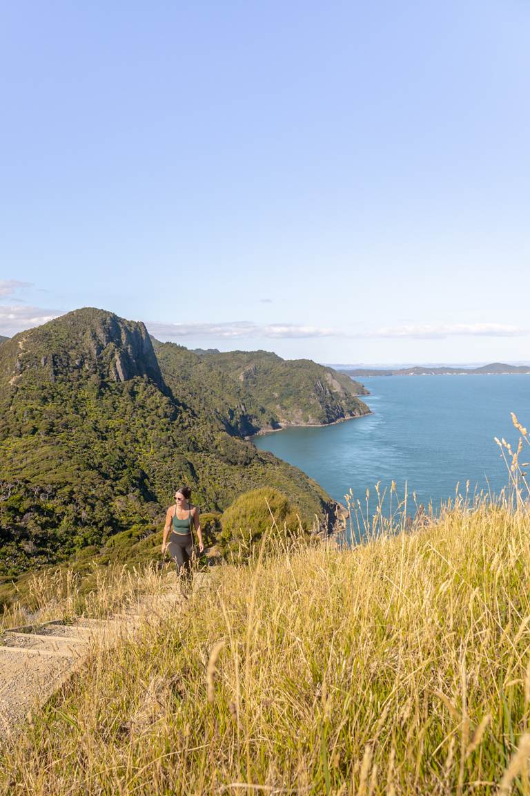
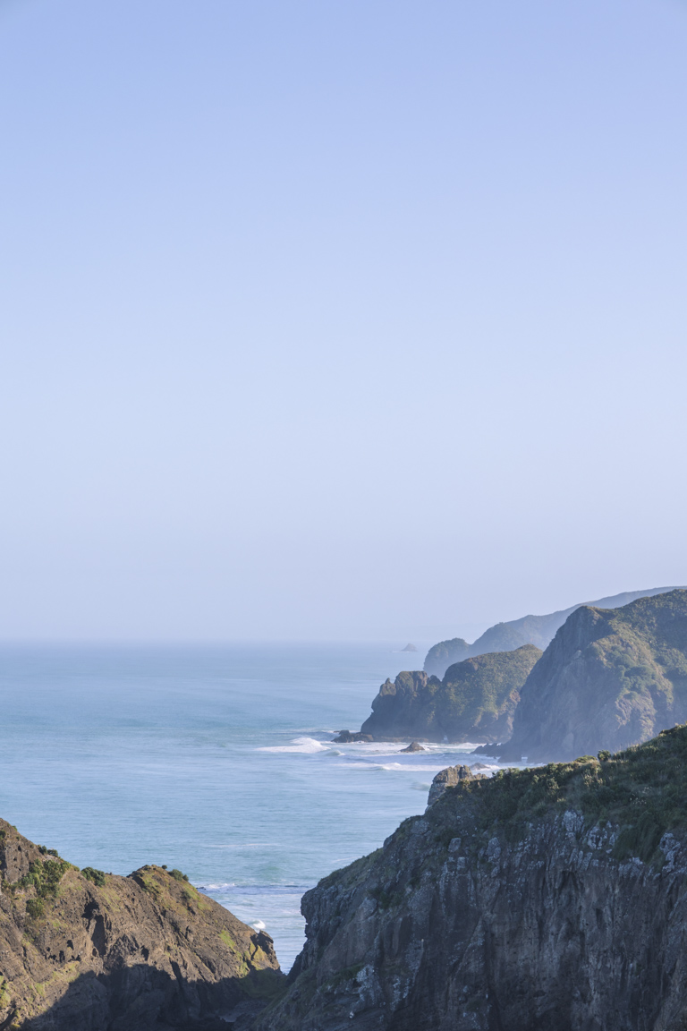
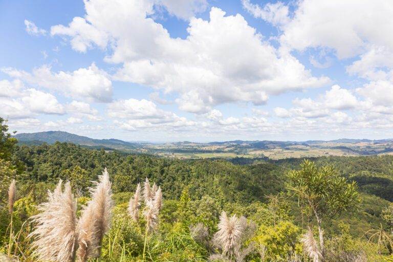
1. OMANAWANUI
Distance: 7.7 km | 4.8 miles
Elevation: 347m
Duration: 2–3 hours
Difficulty: Moderate
Trail Type: There-and-back
Open: Year-round
Starting off strong with an Auckland hike that hits hard is Omanawanui Track. It’s a serious leg-burner with over 2,400 stairs, but those views really pay off.
This steep, exposed out-and-back near Whatipū delivers sweeping panoramas over Manukau Harbour, Whatipū Beach, and the wild west coast. The dramatic drops and endless views make it one of the top spots for golden hour or sunset in the Waitākere Ranges.
I’ve tackled it several times – it’s never easy, but the views never disappoint. It’s perfect for photographers who love a bit of type two fun.
Ready for the challenge? My full Omanawanui Track guide covers all the planning essentials.
2. COSSEY MASSEY LOOP TRACK
Distance: 8.9 km | 5.5 miles
Elevation: 382m
Duration: 2–3 hours
Difficulty: Easy
Trail Type: Loop
Open: Year-round
For a lush forest walk with iconic waterfall access, the Cossey Massey Loop Track in Hunua Ranges Regional Park is a standout.
This loop combines the Cossey Gorge Track and Massey Track, starting near the impressive Hunua Falls. From there, you’ll climb through dense native bush, follow shaded streams, and reach elevated lookouts with views over rolling hills, and the Cossey Dam.
The track is well maintained with plenty of stairs and boardwalk sections, making it accessible while still feeling adventurous. I arrived first thing in the morning on a weekday and while I know this isn’t possible for many people, it was the most ideal time. There were no others at the falls or along the trail, allowing for so much freedom with the camera. If you can manage to swing it, I would highly recommend this as the lighting at this time is also incredible.


3. ACHILLES POINT TO ST HELIERS
Distance: 8.2 km | 5 miles
Elevation: 98m
Duration: 1 hours 45 minutes
Difficulty: Easy
Trail Type: There-and-back
Open: Year-round
For effortless coastal beauty with postcard-perfect island views, the walk from Achilles Point to St Heliers is one of the most accessible Auckland hikes for stunning photography from the CBD.
This gentle there-and-back offers constant harbour views, with highlights including St Heliers Bay, the sparkling Waitematā Harbour, and Rangitoto Island dominating the horizon. The path hugs the coastline, passing beaches and open bays that work beautifully for sunrise or sunset when the light turns golden.
It’s a popular route thanks to its central location, so you’ll almost always be sharing it with others. But if you start at Achilles Point lookout at sunrise, you’re rewarded with a large viewing deck offering panoramic sweeps across the Hauraki Gulf, city skyline glimpses, and scattered islands glowing in early light.
Super photogenic, easy to access, and surprisingly peaceful if you time it right.

OTHER POSTS YOU MIGHT LIKE
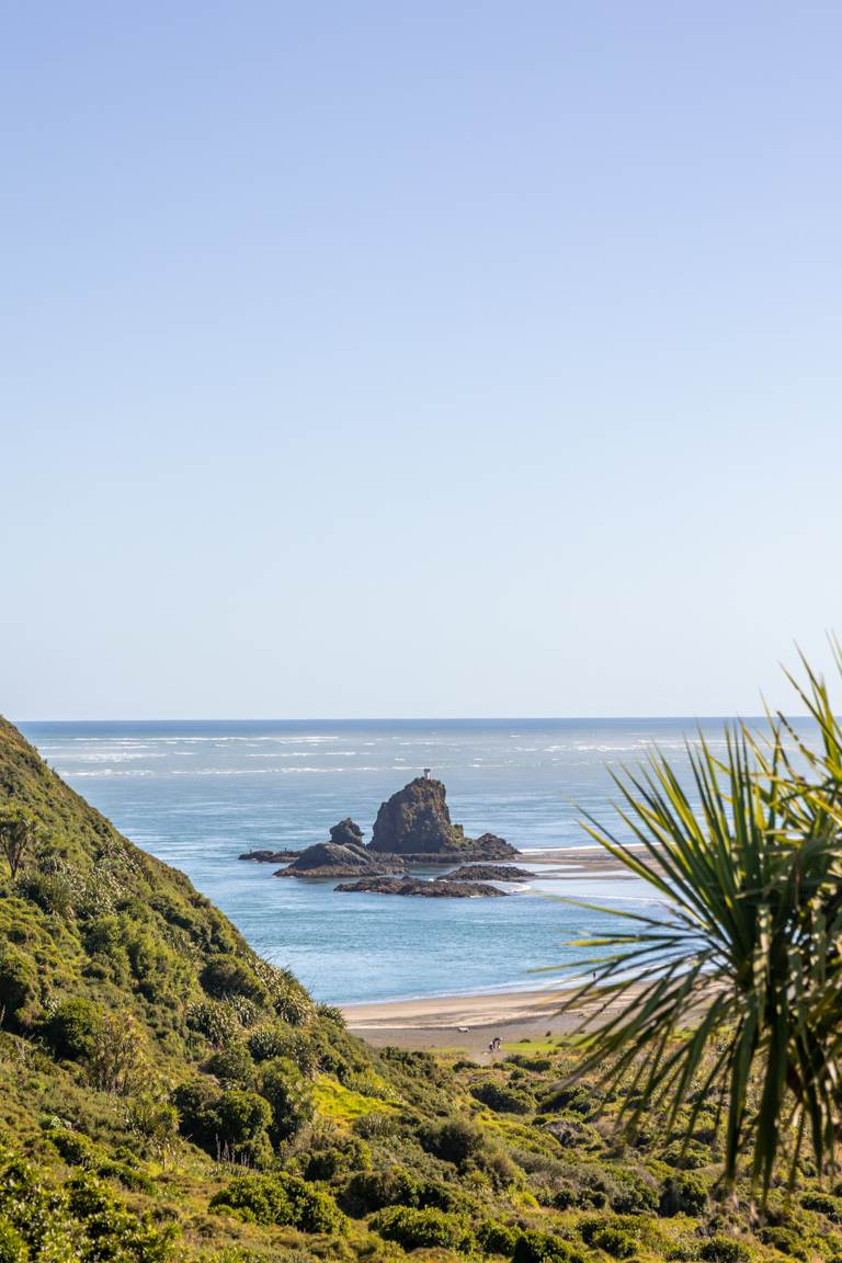
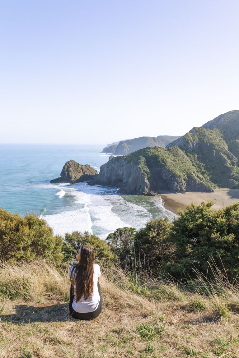
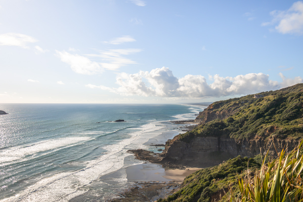
4. COMANS TRACK AND MERCER BAY LOOP
Distance: 7.2km | 4.5 miles
Elevation: 490m
Duration: 2 hours
Difficulty: Easy
Trail Type: There-and-back plus loop
Open: Year-round
Dreaming of a trail that blends lush native forest with jaw-dropping coastal cliffs? This combo in the Waitākere Ranges delivers exactly that and easily earns its place among the best Auckland hikes for stunning photography.
You can start from either Mercer Bay Loop Carpark or Watchmans Road. The full 7.2 km loop mixes inland bush with wide-open ocean scenery, but the shorter 2.3 km Mercer Bay section really steals the show. From the clifftops, you’re treated to sweeping views over Piha and Whatipū Beaches, with the entire west coast stretching out in both directions.
The track is well maintained and there are a few punchy climbs to get the legs working. For photography, sunset and golden hour are unbeatable. It can get busy in summer, but off-season brings fewer people, softer light, and a much more peaceful vibe.
Planning ahead? My detailed Comans Track guide and Mercer Bay Loop post have all the tips you need.

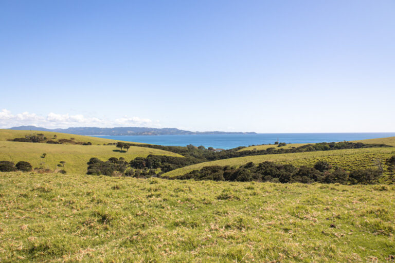
5. TĀWHARANUI POINT VIA NORTH AND SOUTH COAST TRAILS
Distance: 9 km | 5.6 miles
Elevation: 360 meters
Duration: 2 hours 30 minutes
Difficulty: Easy
Trail Type: Loop
Open: Year-round
Craving a peaceful coastal escape that’s still under the radar? Tāwharanui Point in Tāwharanui Regional Park is a hidden gem among Auckland hikes for stunning photography and you’ll find it just over an hour from the city.
This 9 km loop weaves through golden beaches, open farmland, and native bush along the North and South Coast Trails. The constant ocean views, birdlife, grazing sheep, and wide landscapes offer endless imagery to capture.
Easy terrain with gentle hills makes it approachable, and it’s ideal for a relaxed day if you want to pair it with a beach visit. We did this walk first thing in the morning and spent the rest of the day relaxing on the beach and swimming, so this combo I highly recommend!
Weekdays, early mornings or evenings keep it quiet so definitely opt for this if you can.
I’ve detailed everything in this guide here.

6. TE WAHA POINT
Distance: 2.1 km | 1.3 miles
Elevation: 116 meters
Duration: 45 minutes
Difficulty: Easy-Medium
Trail Type: There-and-back
Open: Year-round
After a quiet trail with more birds than people? Te Waha Point ranks high for Auckland hikes for stunning photography. Not only for the bird song, but for the incredible views too.
Perched above Anawhata Beach, this short 2.1 km return track drops sharply then climbs back with a fairly brutal uphill return. But, the lookout does reward you with epic vistas over Whites Beach, rolling waves, and views up the West coastline.
Piha access remains unreliable post-2023 floods, so Anawhata Road is the best place to start. Also adding the nearby Anawhata Beach lookout for sunset is the perfect combination for an afternoon outing.
For the complete scoop – directions, tips, and more, check my Te Waha Point Lookout and Anawhata Beach guides.
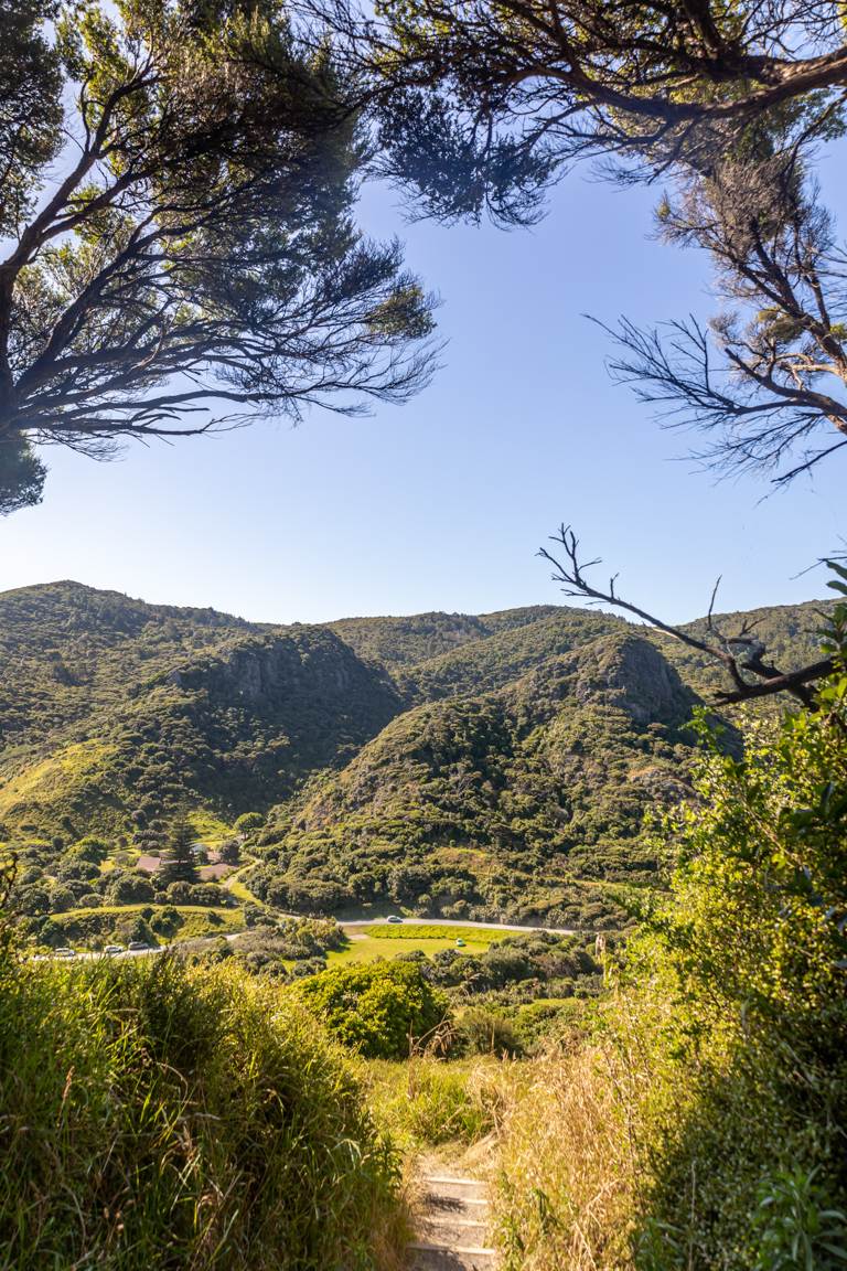
7. SLIP, PIPELINE & BEVERIDGE TRACK LOOP
Distance: 7 km | 4.3 miles
Elevation: 220 meters
Duration: 1 hour 30 minutes
Difficulty: Easy
Trail Type: Loop
Open: Year-round
This Waitākere Ranges loop combines three different trails – the Slip, Pipeline, and Beveridge Tracks and delivers some of the most quietly rewarding scenes among Auckland hikes for stunning photography.
Starting from the Arataki Visitor Centre, the track winds through lush native bush filled with ferns and towering trees. Along the way, you’ll catch serene glimpses of the Lower Nihotupu Reservoir, plus distant city skyline views from several elevated lookouts.
The Beveridge section really shines in the afternoon, and was definitely my favourite section.
Overall, it’s a gentle loop with short inclines, relatively low crowds, and easy access. A relaxed winner for quick photography escapes without needing to commit to a full day hike.

OTHER PINS YOU MIGHT LIKE
8. KARAMATURA TO MOUNT DONALD MCLEAN
Distance: 11.3 km | 7 miles
Elevation: 652 meters
Duration: 3 hours
Difficulty: Medium
Trail Type: There-and-back, including small loop
Open: Year-round
Mount Donald McLean offers some of the most rewarding results when it comes to hiking and photography.
Starting in lush Karamatura Valley, this 11.3 km out-and-back ascends through native bush to twin ridgeline lookouts – one west which looks out over Whatipū Beach, the other east toward Auckland’s skyline, plus sweeping Waitākere and Manukau Harbour views.
Plenty of stairs explain the elevation, but a shorter 10 minute option from a higher carpark exists if timing is tight. The views from Mount Donald McLean give off very similar vibes to Omanawanui but just a little different with more views of the distant city.
Full details and tips, you can find it all in my Karamatura to Mount Donald McLean guide.


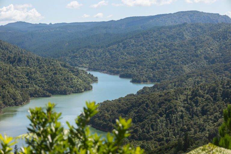
9. WAIROA LOOP AND SUSPENSION BRIDGE TRACK
Distance: 8 km | 5 miles
Elevation: 363m
Duration: 2 hours 40 minutes
Difficulty: Easy
Trail Type: Loop
Open: Year-round
After a lush forest escape that feels worlds away from Auckland? The Wairoa Loop in the Hunua Ranges delivers big time.
This 8 km circuit takes you deep into native bush, crossing a suspension bridge, and follows the valley. The track mixes flat paths, short stair sections, and elevated lookouts with wide views over the Wairoa Reservoir and Dam. Photography wise, there is so much to capture here.
You’ll usually see other people around, but there are plenty of quiet pockets where you can slow down and shoot without distractions. It’s one of the best Auckland hikes for stunning photography if you’re craving more forest over coast.
My Wairoa Loop and Suspension Bridge guide has everything you need to plan your visit.
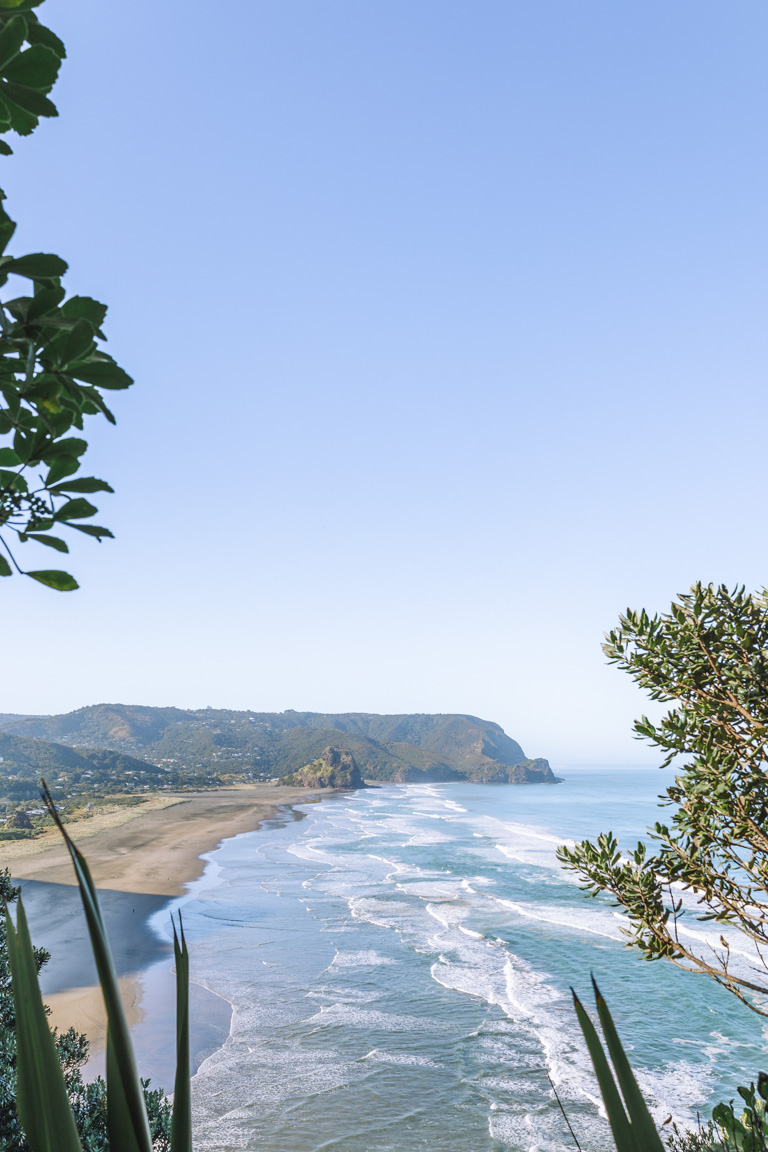
10. TE HENGA WALKWAY, AUCKLAND
Distance: 3.7 km | 2.2 miles
Elevation: 170 meters
Duration: 1 hour 20 minutes
Difficulty: Easy
Trail Type: There-and-back
Open: Year-round
Need a fast coastal hit away from the crowds? Te Henga Walkway is a shorter gem on the list of Auckland hikes for stunning photography.
Located in the Waitākere Ranges, this track forms part of the (partially closed) Hillary Trail. The reopened 3.7 km section from Constable Road near Bethells Beach winds through farmland and bush to Cliff Viewpoint and Tirikohua Point. From here, you’re rewarded with sweeping views stretching from Muriwai to Bethells.
We visited in the afternoon and it was absolutely stunning, with only one other person on the trail. It was a quiet and small adventure, and was paired perfectly with sunset at Muriwai.
As this track operates under partial closures, it’s always best to check DOC for updates. My full Te Henga guide has the latest tips and access info.
CONCLUSION
These Auckland hikes for stunning photography capture the best of what makes Tāmaki Makaurau so special. With dramatic west coast cliffs, serene forests, iconic island views, and peaceful coastal loops, you’re in for a treat.
From the leg-burning stairs of Omanawanui to the effortless golden-hour glow on the St Heliers path, each one has delivered me unforgettable shots and those “this is why I hike” moments.
Pick one (or a few) based on your time and energy – they’re all year-round winners, but golden hour or early mornings often give the softest light and fewest people.
If you’re hungry for more adventures like these, check out our other New Zealand travel guides for trails, photography spots, and outdoor escapes across the country. To explore all our locations and ideas, head over to our international destination guides.
LIKE THIS POST? PIN IT HERE
FAQs
What’s the best time of day for photography on these Auckland hikes?
Golden hour (sunrise or sunset) is king – especially on west-facing trails like Omanawanui, Mercer Bay, Te Waha Point, Mount Donald McLean, and Te Henga. Early mornings often mean softer light, fewer crowds, and better chances for reflections or bird shots (e.g., at Tāwharanui or Cossey Massey).
Are these trails crowded, and how can I avoid people in photos?
It varies: Waitākere spots like Mercer Bay and Omanawanui get busier in summer and weekends, but off-season (winter/spring) or weekdays/early mornings keep them quieter. St Heliers to Achilles Point is popular due to its CBD access, so sunrise starts help. Inland loops like Slip/Pipeline/Beveridge, Wairoa, and Cossey Massey are generally peaceful with plenty of quiet pockets.
What gear should I bring for photography on these hikes?
Your camera, a tripod for low-light/golden hour shots, wide-angle lens, and a telephoto for birds/island details (if needed). Good hiking boots are essential, plus a pack with water, snacks and layers (weather changes fast). Also make sure to check DOC for the most up to date information on trails.
Which trails are best for beginners or families wanting good photo ops?
St Heliers to Achilles Point (flat, easy access), the Beveridge section of the loop (gentle bush/reservoir scenes), and Tāwharanui Point are super approachable.
Are there any seasonal considerations or best times of year?
Year-round access, but winter/spring bring lush greens, and fewer crowds. Summer offers longer days and beach combos (Tāwharanui), but expect more people and drier west coast tracks. Always check Metservice/DOC for weather, tides (some coastal sections), or slips.
Do I need permits or is there entry fee?
All free and no permits required. Just ensure to park responsibly (some carparks fill early) and follow Leave No Trace principles.
Which ones offer the most dramatic views for sunset/golden hour?
Any of the trails along the West Coast – Omanawanui, Mercer Bay, Mount Donald McLean, Te Waha Point, and Te Henga.
Top Travel Resources to Plan Your Next Trip
Finding the Best Flights
Skyscanner: A great platform for comparing flight prices across airlines and routes.
Omio: Perfect for comparing not just flights but also trains and buses, especially for European travel.
Booking Your Stay
Hostelworld: Ideal for those specifically looking to budget on their travels and seeking hostels, guesthouses, or shared accommodations.
Booking.com: With a massive selection of hotels, apartments, and unique stays, this platform additionally has deals for frequent travellers.
Trivago: A powerful search engine for comparing hotel prices across multiple booking sites to find the best deals for your stay.
Renting a Car
Europcar: Offers a wide range of vehicles for hire in New Zealand and worldwide, perfect for exploring at your own pace.
AVIS: A trusted car rental service with a variety of vehicles and locations, ideal for seamless travel adventures.
Travel Essentials & Gear
Amazon.com: Your one-stop shop for travel gear, gadgets, packing essentials, and last-minute trip must-haves.
Discovering Amazing Activities
GetYourGuide: My go-to for booking tours, tickets, and activities in New Zealand and worldwide.
Everything New Zealand: A must for anyone traveling to New Zealand. This platform offers a curated selection of tours, activities, and adventures to make your Kiwi trip epic.
G Adventures: For small-group tours with a focus on sustainable and authentic travel, G Adventures is unbeatable.
Capturing Your Memories
MILK Books: Create stunning photo books to preserve your travel memories. Expect high-quality prints and customisable designs.
These links are affiliate links. If you book through them, I earn a small commission at no extra cost to you. Your support helps me keep sharing guides like this. Thanks for helping fuel the next adventure!
LATEST FROM THE BLOG
A SUMMARY OF AUCKLAND HIKES FOR STUNNING PHOTOGRAPHY
Post Overview: Curated guide to the top 10 Auckland-area hikes ideal for landscape, coastal, forest, and wildlife photography. Features personal insights, stats, tips for best light/timing, and why each delivers epic shots–from west coast ridges to Hunua waterfalls and Rangitoto views.
Key Stats & Variety: Trails range from easy 2-9 km loops/there-and-backs (e.g., Te Henga 3.7 km, St Heliers 8.2 km) to moderate challenges (e.g., Omanawanui 7.7 km with 2,400 stairs, Mount Donald McLean 11.3 km). Elevation 98–652m; durations 45 mins–3+ hours; all year-round, free access.
Best For: Photographers (golden hour, reflections, birds, panoramas), nature lovers, day trippers from Auckland (most within 1–2 hours drive). Mix of Waitākere Ranges (coastal/bush drama), Hunua Ranges (forest/reservoirs/waterfalls), and eastern/northern coastal gems.
Highlights by Trail: Omanawanui (sweeping harbour/west coast panoramas); Cossey Massey (Hunua Falls, dam, lush bush); St Heliers to Achilles Point (Rangitoto/harbour island views); Mercer Bay (clifftop ocean drama); Tāwharanui (beaches, farmland, birds); Te Waha Point (quiet wild beach overlooks); Slip/Pipeline/Beveridge (reservoir/forest intimacy); Mount Donald McLean (twin ridgeline city/west views); Wairoa Loop (suspension bridge, reservoir lookouts); Te Henga (Muriwai-to-Bethells sweeps).
Tips & Practicality: Prioritise golden hour/early mornings for light and solitude; check DOC for updates (floods/closures in Waitākere); good boots/water/layers essential; pair hikes with beach swims or sunsets. Low crowds off-peak; family-friendly options available.
Why Read This: Get firsthand recommendations, photo-specific advice (timing, compositions), linked full guides, and inspiration to capture Auckland’s diverse scenery without long treks.